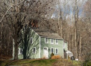
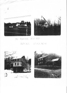
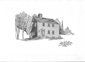
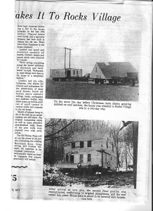
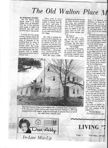
This early “half-house” was moved in two pieces from a site in New Hampshire, and was reassembled in Rocks Village. A large corner fireplace was suggested by its frame and reproduced. The frame is truly massive and suggests an early date. The ell on the right adds modern living spaces without compromising the “feel” of the house. (34)
Originally owned by Swett and sold to Simeon Brown in 1745, this land has mostly remained as part of a 5 or 8 acre tract of land until the 1970s. The larger piece of land often included 38 East Main and was owned by Brown, Esterbrook, Davis, Young, and Carleton. Sometimes called a woodlot or Tarbark, this land contains springs.
Andrew J. Young’s Shop was on this land when Young owned it from 1868 – 1894 (7)
Lydia Davis acquired it when Joseph Esterbrook Sr. died in 1861, along with 34 Wharf Lane, for payment of a $2,000 debt.
It borders Back Lane (earlier called Cutting’s Lane) and the line between Haverhill and Historically Amesbury, now Merrimack, MA.
House was moved in 1975 to this location.
Deeds
1745, Nov 27: John and Sarah Swett to Simeon Brown (Physitian) (87/139) near Swett’s Ferry : bounded easterly on the road that is laid out from the landing to the road that leads to Merrimack River near the XXXX XXX between Haverhill and Amesbury. Northerly on the highway leading from Jamaica Path to the said XXXX XXX, westerly on Jamaica Path, southerly partly on landing and partly on the county road that leads to said Swett’s Ferry. 19 or so acres
1745 (recorded): Simeon Brown to James Bowdoin. Same land as above (Mortgage) Paid off (132/17 between Henry Young Brown and William Bowdoin 1773, June 30th)
1773, July 3: Henry Young Brown, Ruth Brown, and Simeon Brown to James Carr (134/22). 19 Acres. Bounded northerly on starting at bound rock and road leading to Jamaico path, westerly by Jamaico path, southerly by highway that leads from Kingstown to Swett’s ferry in part on landing, easterly by 2 rod way to bound first mentioned.
1805, July 11: Francis Carr to Frederick Parker (4 acres) (179/109). Beginning and s&s and road called Swett’s Road and running 27R to s&s and running westerly along Cutting’s Lane etc.
1820 Frederick Parker dies
1855 Widow of Moses Brown owns according to deed (516/129)
Widow of Moses Brown was Abigail. Abigail Burroughs (1776 -1859) married 1) Frederick Parker (1771 – 1830) in 1796, 2) Moses Brown (x- bfr 1855) in 1832
1827: Potentially, Joseph Estabrook gets this land because he marries Ann Parker (maybe Frederick’s mother/sister)
1867, Apr 29: Ann M Estabrook (John L’s mother, John R’s wife), J. L. Estabrook and Mary E. Estabrook to Lydia A. Davis (727/138), Due to $2000 debt to Davis in will. $1,300 for this piece and 34 Wharf Lane. 5 acres more or less.
1868, March 30: Lydia A. Davis to A. J. Young (from New London, NH) (743/157) $1000.00. 5 acres more or less. This deed also includes 34 Wharf Lane.
1889, Jan 11: Andrew J. Young to C. B. Young (1240/233) for $1.00 and other considerations.
1889, Dec 10: C. B. Young (unmarried) to Andrew J. Young (1273/16) A certain lot of land with Buildings. Beginning at highway and land of Abigail George thence westerly by Abigail George to land of Mr. Elliot, then northerly by land of Elliot and land of Hayden Brown, thence westerly by land of Hayden Brown, then northerly by Brown’s land to road leading from Rocks Village to South Amesbury, then easterly and southerly by said road to Ann W. Esterbrook and others, thence westerly and southerly and southeasterly by land of said Ann W. and others to land of John Osgood, thence southerly by Osgood’s land, thence westerly then southerly by Osgood’s land and land of James Davis and others to land of John B. Nichols, thence westerly and southerly by said Nichols land to the road first mentioned and then easterly by road to the bound first mentioned. Easterly is underlined to suggest this is incorrect.
1894, July 30: Andrew Young to John N. Hunkins and Flora A. Hunkins (1419/35) 5 acres more or less
1905, Sept 6: Hunkins to Merrimac Savings Bank (1791/409) 5 acres more or less
1912, Nov 6: Merrimack Savings Bank to Augustus L. Bragdon and Alice E. Bragdon (2186/290/292) discharge 3520/97 in 1947.
1930, March 24: Augustus L. Bragdon to Andrew O. Nicol (2839/286) 5 acres more or less
(1930, March 26: Andrew O. Nicol Mary H. Nicol to Merrimac Valley Development Corp. (2839/287) 5 acres more or less
1949, Nov 30: Merrimac Valley Development Corp to Caroll L. and Mary A. Barton (3546/588). 5 acres more or less including 38 East Main.
1959, Sep 14: Joan Bancroft to Carroll L. Barton and Mary A. (4599/38). 5 Acres.
1971, Apr 22: From Carroll L. Barton to Jerry Lischke. 38 East Main was split off parcel. (5760/441)
1974, Jun 12: Carroll L. Barton to Jerry C. Lischke and Catherine E. Lischke (6074/30) 5 acres more or less.
1987, Jul 2: Jerry C. Lischke and Catherine E. Lischke to Kenneth R. Dym and Anne C. Bauer (9063/281)
1988, Feb 11: Kenneth R. Dym and Anne C. Bauer to Kent L. and Karla L. Kirkland (9396/288)
1992, Aug 7: Kent L. and Karla L. Kirkland to Gary T. and Ellen F. Matsell (11423/259)
1999, Sept 30: Gary T. and Ellen F. Matsell to Stephen Pike and Janene Ann Leroy (15967/146). Lot 1 plan book 227, page # 51