Seven River Road is the closest property to what is now the Hand Tub House land. In the early years, the deeds seem to suggest that it was chopped up into quarter acre lots and sold several times. As most of the property in Rocks Village it was owned by John Swett and probably part of the landing.
Joseph Burrill owned this land as well as 15 River Road and was a shipbuilding. He married Hannah Esterbrook and apprenticed her son Samuel Esterbrook as a shipbuilder. In 1761, Joseph Burrill and Hannah Esterbrook Burrill sold 7 and 15 River Road to Samuel (1738-1778)
In 1785, this house lot was split from 15 River Road and sold to Samuel’s Son, Samuel Jr. (1762-1793)
Lt. Samuel Esterbrook III served as a soldier during the Revolutionary War. He was a cooper and is also listed as a shipwright. Married Hannah Silloway June 16, 1784.
1733/4, Feb 12: John Swett to Josiah Copp (70/149). on southwest by brook 5R6′, on west by two rod way 11R, on north 5R6′, and on east by River 8R12′. Mentions an open way of 2 rods.
1737 Jan 12: Josiah Copp sold land to Benjamin Swett (81/269) A Quarter or fourth part of an acre lying in Haverhill near a landing known as Plank’s landing. Bounded starting at the southwest corner of stake and stone on the north side of the little brook then running easterly about 4 rods to another s&s to Merrimack river and then and then running easterly on river about 9 rods to another s&s adjoining land of Enoch Brown on the north of the bound, northerly on Brown land about 6 rods to another s&s and then to extend southerly to bound first mentioned.
1740, Aug 12: Benjamin Swett to George SantClar (81/18) One quarter of an acre. At the southwest corner a s&s on the north side of the little brook extend easterly 4R to another s&s to Merrimac River, then bounded by river for 9R to another s&S joining land of Enoch Brown, then bounded northerly about 6R to another S&S, from thence extended to bound first mentioned. At or near a landing known as planks landing.
1748, Apr 18: George Santclar to Chrisp Bradbury (101/62) Starting at southerly corner on north side of little brook. then running easterly 4 R along brook. Northern border Barnabas Bradbury. River on East.
1750, May 6: Chrisp Bradbury to Beniah Young (100/160) looks like mortgage. references land bought from George Santclare. Only two deeds from Benaih Young in Haverhill. One to Henry Morse (when Beniah dies 1797 two large parcels on river) and one to Theopholis Colby (three acres)
1761: Burrill sells 7 and 15 River Road to Samuel I (121/162)
1784, Jun 16: Hannah Silloway marries Samuel Easterbrooks, jr.,
Children: Joseph, born August, 1786; Abigail, November 12, 1788 ; and Samuel (III), born March 20, 1792.
1785, December 1: Samuel Esterbrook (I) gentleman and Hannah Esterbrook to Samuel Jr. (II) (163/211) a cooper, part of his house lot situated on the river side of the Amesbury Road. (7). Bounded by brook, road 4.5 rods, Esterbrook Jr., River 3.5 rods to brook. This breaks off 7 from 15.
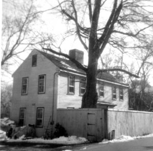
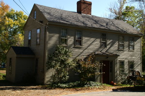
1786: Samuel Esterbrook Jr. built
1793: Samuel Estabrook Jr., shipwright and cooper, died. The property passed into the hands of his heirs. Several deeds in 1798-1799 for adjoining properties mention this attribution.
1819: Joseph & Lydia Estabrook and Daniel and Abigail (Estabrook)Elliott (children of SE Jr.) sell to their brother Samuel Estabrook (III) (235/115 and 116), the parts that they inherited from their father Samuel Esterbrook. No dimensions given.
1850 census:
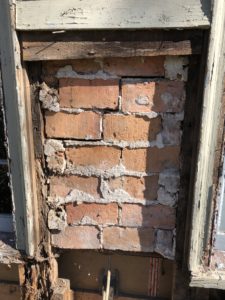
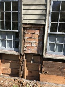
821-1039  Samuel ESTABROOKS (III), 58, bricklayer, $500
          Sophia ", 58
          Eliza ", 21
          Sarah ", 19
          Jonathan MAXWELL, 28, bricklayer, ME
          Eliza GEORGE, 50
1856 map lists Samuel Estabrook
1869, May 13: Samuel Estabrooks III (of West Newbury) to James (shoemaker and farmer) and Betsey A. (Hull) Oakes (of west newbury) (778/146) Deed and Mortgage, Discharge of Mortgage (1873 (913/16) 82.5 feet along Road, bounded on north by SE’s land, 71 feet on River and south by Town Landing. $800
1870 census:
James Oakes (45) Shoe contractor
Elizabeth Oakes (38) Keeps House
Hall, William (25) works in shoe factory
In 1870, a James Oakes is listed as a shoemaker living on River Road in RV
1872 Map: J. Oakes
1892: James Oakes listed on Map
1900 census
James Oakes (75) shoemaker
Bessie Oakes (57) married 40 years
Both came from Ireland in 1858
1901, June 12, James Oakes Dies
Bessie A. Oakes wills property to her niece Theresa (Hull) Colby
1908, Aug 3: Theresa Colby to Mortimer George Gray (1930/289-290)
1911, Feb16: Mary Charlton Gray (probate from Mortimer George Gray) to Henry B. True (2067/441) $550.00
Franklin Bagley True Dow to Minnie W. Witham in True’s will
1924, Apr 18: Minnie M. Witham (unmarried) to George W. Hull (single man) Bounded north by land now or formerly owned by Ramsey, east by Merrimack River 71′, South by brook and city landing, west by river road 82.5′ containing 20 rods more or less. (2389/336)
1940 Census: William A. Hull – 55, George – 56 (brother), Charles – 28 (Nephew), Stella – 23 (Niece), William C. – 5.5 (Nephew)
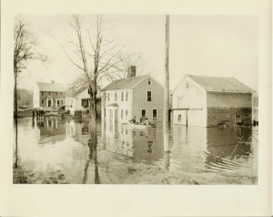
Barn Collapsed in the 40’s.
1951, Jan 19: Land is taken from George W. Hull for payment of Taxes (3837/448)
1952: George gets land back (3884/514) Map 430, Block 4, Lot 2: 19,600 sq ft.
1953, Jan: Release of lien (4157/243)
1954, Jan 3: Heirs of George W. Hull (Helen P. Little, Charles J. Hull, Hulbert A. Hull, Minnie G. Baron, Mary Jane Hudson, and Alice M. Cook) to William A. Hull (4157/244)
(William A. Hull Probate (280900) to Charles and Stella Hull.
1966, Apr 18: Charles J. Hull and Stella D. Hull to Owens (5354/207) ~$8,000
1966, Apr 11: Harry W. Colby to Owens (5354/206) bounded by 12 feet on River Road, Land previously of oaks, 12 feet on Merrimac River and land formerly of Colby and formerly of Leary. (This looks like it is 12 feet towards Deacon Phineas Nichols House) 1916, Sept 12: William M. Ramsey and Cora M. Ramsey to Harry W. Colby (2342/115) Burrill’s Land (84 feet along road)
1967, July 11: Robert F. Owens and Patricia Owens to Crandall (5459/35) $16,500
1973, Aug 17: David P. and Susan F. Crandall to Presberg (6005/472) $34,250
1981, May 15: David L. Presberg and Carole L. Presberg to Buba(6820/345)
1983, Sept: Felix E. Buba and Joanne Willis Buba to Wilkinson (7216/476)
1989, Aug 1: Peter H. Wilkinson and Dianne F. Wilkinson to Lemieux (010093/593) 83 feet (5R) along river and 94.5 (5.7R) feet on road.
References:
1906: Warren Wallace – shoemaker
1920: Charles Carr – Shoemaker