From Whittier Land, by Samuel T. Pickard, 1904, p. 51 Footnote 1:
This letter has been published in full in a limited edition, by Mr. Goodspeed, together with a New Year’s Address referred to in it as having given offense to some of the citizens of Rocks Village. A portion of this Address (which appeared in the Haverhill Gazette, January 5, 1828) is given in Life and Letters,[by the same author] pp. 62, 63. The lines that seem to have given offense are these :
— ” Rocks folks are wide awake
— their old bridge tumbled Some years ago,
and left them all forsaken ;
But they have risen, tired of being humbled,
And the first steps towards a new one taken.
They ‘re all alive — their trade becomes more clever,
And mobs and riots flourish well as ever.”
Bridge Timeline
1711: Before the bridge was built, there was a ferry at the same location. John Swett Jr. of Newbury was authorized by the town of Haverhill in 1711 to operate a ferry across the river at the “Rocks”. When he died in 1725, he left his son, John Swett III, the rights to the ferry. The son renewed the license over time as he continued to operate the ferry for many years. John Swett (either Jr. or III) was also licensed to keep a tavern at ‘the Rocks’ before 1728 at a time when there were only two taverns in Haverhill.
1778: When John Swett III died in 1778, he bequeathed the ferry to his grandson James White since he had no surviving sons. White continued to operate it until he moved away to Vermont in the early 1790’s.
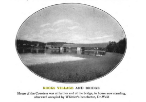
1794: The original bridge at Rocks Village over the Merrimack River was named Merrimack Bridge. It was built in 1794 and completed on Nov 26, 1795. The first proprietors of the bridge were Enoch Sawyer, William Coffin, Joshua Wingate, William L. Abbott, William Cutler, Jacob Brown, Joseph Newell, Amos George, Ephraim Elliott, and Moses Moody. The act, approved June 14, 1794, specified the bridge should be erected between the public landing place at Swett’s Ferry, to the opposite shore in Newbury, the town of West Newbury not having been set off from the other town until 1820.
900 ft long, 30 ft wide, “with an arch 140 feet long over a good depth of water. The arched part had a crown, there was a draw 30 feet wide, which the act specified, “Shall be opened without pay or toll at all times.” “Said bridge shall be covered with plank or timber, and sides boarded and railed at least four feet high for the security of passengers.” “Said bridge shall be furnished with at least four good lamps which shall be supplied with oil, and kept burning through the night……”
The bridge was run by a group of private investors, the Merrimack Bridge Company. The group was made up mostly of men from the village. They were responsible for repairs and maintenance, and they collected tolls. There are many probates from the time that left “one share Merrimack Bridge” to their heirs.
1803: The “Mail Stage” from Haverhill to Newburyport ran over the bridge on Tuesday. It costs .75 cents to go from Haverhill to Newburyport and you were allowed 14 pounds of luggage.
1811: From John Ingersoll’s diaries there is work being done on the bridge and the piers. He received $3.80 for his part of the toll in Aug, $2.87 in Sept (seems like 1/4 part). Ingersoll also tended the ferry in this summer.
1813, December 11: The Merrimack Intelligencer” proclaimed: Take Notice: The Public are now informed that the Merrimack Bridge is now passable and safe for droves o’ cattle, loaded wagons, or any thing which may wish to pass; having been repaired by Major William Carr since it was broken through by a drove consisting of 100 cattle huddling together on one of the arches. Caleb Kimball, Moses Brown, John Ingersoll – Directors. (21)
1814, Feb 26: “went over the river to Brown’s Tavern where there was a meeting of the directors of the Merrimack Bridge. The toll taken at said bridge the last quarter was $189 and the amounts allowed at the meeting amounted to $309.76.
1814, May 30th: meeting of the proprietors of M. Bridge which was held at Brown’s Tavern: Caleb Kimball, Paul Bailey, Moses Brown, John Ingersoll, Phillip Bailey where chosen as directors (from John Ingersoll diary).
1814, Aug 31: John Ingersoll went over to Newbury to a bridge meeting at Brown’s Tavern.
1814, Nov 28: “P.M. went to a meeting of the Directors of M. Bridge held at Brown’s Tavern. The money taken last quarter is 313$ orders allowed….. This was the same night as an earthquake and meteor.
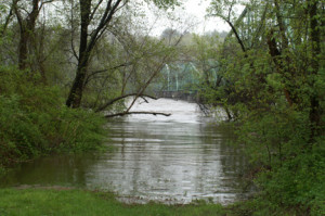
1818 – The bridge was destroyed by an early spring “freshet” brought on by heavy rains and snow melt from a winter of heavy snowfall. Water was 21 feet above normal high water, exacerbated by ice dams of 2-foot thick ice. The streets and houses were flooded, many cattle were drowned. Row boats were deployed to carry goods to higher ground. The Haverhill-Bradford bridge received a pummeling too, but held. The Merrimack Bridge held for awhile, and then suddenly with a crash like an explosion it fell into the water and was carried out to the sea with the ice. (68, pg277)
1818 – 1828 – John Johnson (by now Col. John Johnson) operated a ferry. He was by now one of the bridge proprietors, although there was no longer any bridge. Haverhill leased “the old ferry” to Johnson at $44 per year. Many disagreements ensued between Haverhill and West Newbury on how to handle the profits from the ferry. He also operated a Tavern on E. Main Street.
 1828 – The state authorized the proprietors to build a new wooden covered bridge “upon the old foundations” (4 stone piers and 2 abutments). George Foot was Clerk of the proprietors at that time (probably a relative of Enoch Foot). The original articles of incorporation for the old bridge needed to be amended (they called for one arch 140 feet long, 30 feet wide). But the proprietors proposed and were granted to build a new bridge, 900 ft long and 22 feet wide, with a 36 foot wide opening draw. It was built on “Town’s plan”. There were also 4 defensive piers extending a distance above it.
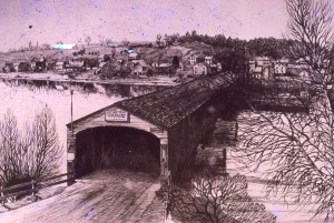
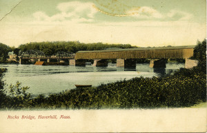
The bridge was completed by October/November (1828 Merrimack Bridge completed on Towne’s System). It was apparently open in time for the cattle show in W. Newbury, and a notice was posted in the Newburyport Herald announcing the opening declaring “it is built of plank (except the floor timbers), and for simplicity, strength and durability is considered inferior to no bridge ever invented.”
Covered bridges helped the horses and cattle to not be afraid of crossing over the bridge.
1830 Census:
Merrimack Bridge. Incorporated 1794.
Richard Stuart, President; Moses Newell, Vice Pres.;Enoch Foot, Treas.;George Foot, Clerk.(38)
On each end of the old bridge there was a sign, stating that
driving a horse faster than a walk was forbidden, and a fine for not
obeying. (Notes from the Chase Chronicles)
The first tollhouse was built about this time.
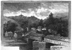
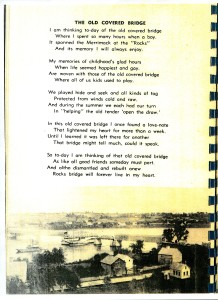
The new bridge had only a few small windows and 4 oil lanterns to provide light. This is the bridge immortalized by John Greenleaf Whittier in “The Countess”:
“Over the wooded northern ridge
Between its houses brown,
To the dark tunnel of the bridge
The street comes straggling down.”
1832 Map indicates it to be Merrimack Bridge
1851 Map calls it Merrimack Bridge and indicates the Toll House
1856 – John Ladd was tollkeeper of the bridge and a shoemaker in the cobbler’s stall by the bridge. He lived at 15 Wharf Lane with his wife Sophia Jaques.
1857 – Wallace T. George (John Ladd’s nephew), father of Edward B. George, Clerk of Courts of Essex county, was tollkeeper. The most prosperous year for receipts of the bridge. “George” is another name in Rocks Village history: Gideon George and Moses George each owned a house in the village in the 1800’s.
1858 – Theodore Ordway was tollkeeper and shoemaker. He took the last receipts collected. Later his son Charles Ordway took over shoemaking and tending the draw.
1868: By an act of the general court, the toll bridges across the Merrimack became public highways and the county commissioner awarded the stock holders of Rock’s Bridge 30 cents on the dollar for their shares.
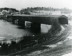
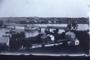
 1873 – An iron span was installed to replace the draw. The bridge had been found to be in bad condition, especially the draw. The county paid for the new draw, and the three adjoining towns paid for the repairs. The Haverhill side of the bridge was repaired. Rocks Village residents felt the repairs were inadequate so more repairs were done later the same year.
1875 Annual Report from Haverhill: $755 spent on services and repairs (Theodore Ordway, Stephen Noyes, D.D. Chase and sons Lumber, Smiley Brothers, Taylor, Goodwin and Co. Lumber.
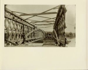
1883 – An iron swing was installed to replace the iron span.
This is the time period when Mrs. Frederick Kimball of Rock’s Village wrote her spicy verse, published in the Haverhill Bulletin in June, arguing for the repairs to be made. The amount expended by the towns was $2100.35 for the repairs.
1890 – The bridge was replanked. A new drawtender’s house was built close to the bridge and was also used for shoemaking.
1892: The two piers closest to West Newbury we strengthened.
1893-4 – Extensive repairs were done. W. Newbury side remained in wood, but was strengthened.
1912 – Haverhill Evening Gazette Dec. 13, 1912: “The present drawtender is John Germaine …occupies the old tollhouse, where he repairs shoes, and it is still ‘a cobbler’s stall’”
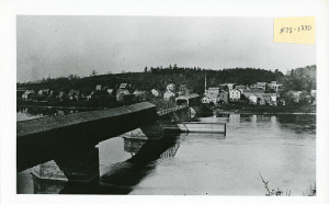
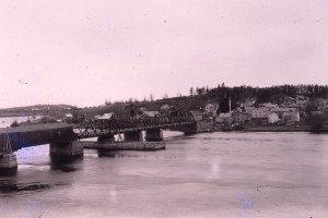
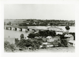
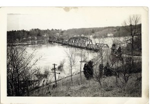
1912 – 1915 – W. Newbury section torn down and replaced by a steel structure with cement flooring, although residents tried to save the old wooden bridge. In an article it was stated: “Parts of the original structure still remain.”
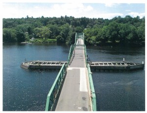
1914: Current Bridge Design
1964: Pilot, ejected from plane during crash, landed in a tree on the banks of the river near the Rocks Village Bridge.
1973 –Discussions on bridge repairs and capacity issues, increased traffic, and bridge historic preservation took place among local residents, the Rocks Village Memorial Association, the Merrimack Valley Planning Commission, and Mass. DPW. Plans were laid for the MVPC to perform an environmental impact study to investigate alternatives to the bridge. Actual implementation of the recommendations of the study would begin 5 or 6 years later to allow sufficient time for the study itself as well as approvals from Washington. Current capacity of the bridge: 10 tons. The DPW representative said that there were no plans to build a connector from Rte. 95 to Rte. 495 over the village, as had been feared.
1974: The Haverhill part of the bridge was Incorporated into the Massachusetts Local Historic District: Rocks Village Historic District.
1976: Bridge on the National Register of Historic Places
2014: Refurbished by MassDOT project.
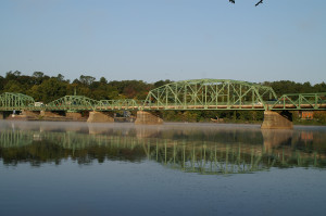
The swing span, built in 1883 by Boston Bridge Works, is the only remaining manually-operated swing span in Massachusetts.