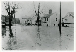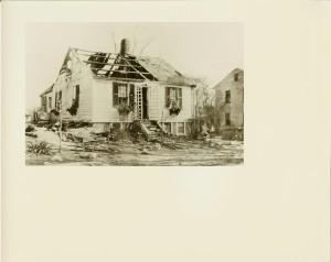
This house no longer exists as it burned down in 1936 just after the flood. It was one of the four houses in the village in 1750 and was situated between what is now 7 River Road and Phineas Nichols House.
The cottage of Mrs. Hannah Ramsey was once owned by Samuel Easterbrooks, who married Hannah Silloway, in which the second chimney is doing service, the first having been removed many years since. (Peaslees and others...)
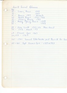
Joseph Burrill’s account book starts in 1743.
1743/44, Feb 9: Joseph Burrill marries Hannah Esterbrook (the widow of Elijah Estabrook) in Newbury. One of her son’s, Samuel, was 5 or 6 at the time being born Nov 27, 1738. (39)
Throughout Burrill’s account book, there are references to Samuel being a Shipwright Apprentice.
1733/4, Feb 12: John Swett to Josiah Copp (70/149). A Quarter of an acre bounded on southwest by brook 5R6′, on west by two rod way 11R, on north 5R6′, and on east by River 8R12′.
1737 Jan 12: Josiah Copp sold land to Benjamin Swett (81/269) near a landing known as plank landing. Quarter acre on Merrimac River bounding by Little Brook and Enoch Brown. At or near planks landing.
1740, Aug 12: Benjamin Swett to George SantClar (81/18) 9R along river. North by Enoch Brown 6R, South by Brook. At or near a landing known as planks landing.
1748, Apr 18: George Santclar to Chrisp Bradbury (101/62) 4 R along brook. Northern border Barnabas Bradbury. River on East.
1750, May 6: Chrisp Bradbury to Beniah Young (100/160) looks like mortgage. references land bought from George Santclare
1750, Sept 10: Chrisp Bradbury to Stephen Blaidsdell (98/71) bounded by River. Includes Shop standing on “my” building yard.
1750, Mar: Stephen Blaidsdell to James McHard (98/62). Near Holt’s Rock. Bounded Westerly and Northerly by Simeon Brown. House and barn and 1/4 of an acre.
1766, May 29: James McHard to David Nichols (120/77) Near Holt’s Rocks so called, House and barn and 1/4 acres of land. bounded by Simeon Brown westerly and northerly, and by the other sides by highway or common landing.
1761, Jan 12: Joseph Burrill Shipwright sells land to Samuel Esterbrook Sr. Gentleman (and Burrill’s apprentice and stepson) (121/162). 19 pounds, 6 shillings, 8 pence. Along road 4.5 R, southerly by Burrill land to River 5R, north along river 4.5, north along Nichols land 5R to beginning. 20 rods of land and includes Barn.(This breaks off land from 7 River Road).
1765, Aug 7: Samuel Estabrook (Shipwright) to Dudley Atkins (esq). (121/163). Along road 4.5 R, southerly by Burrill land to River 5R, north along river 4.5, north along Nichols land 5R to beginning. Includes Barn. Mortgage for 20 pounds
Dudley Atkins dies in 1767. Sarah Atkins his widow. Probate 938. Daughter Mary Atkins 14 years old.
1782: Samuel Esterbrook
1799, Sept 18: Samuel Estabrook (Shipwright) administrator Edmund Brown, to John Brown, Jr. (cordwainer) for $150.00 (204/168). bounded by way 4R 20L, Enos Bartlett (jog that is 25′ east, 14′ north, 4R 3.5′ east to river, River 6R, Samuel Estabrook 6R.
1802: Aaron Peaslee owns 25′ by 14′ jog that makes up 387′ (where Nichols blacksmith shop is)
Aaron Peaslee is in jail from 1804 to 1808 for making counterfeit money plates. He was an engraver and die-sinker.
1805: John Brown and Aaron Peaslee
1808: Aaron Peaslee to John Brown (204/167). This is a piece of land that is 25′ x 14′ bounded by Joseph Poyen and John Brown.
1822 John Brown
1825, Apr3: John Brown to Enoch Foot, Benjamin Chase, John Osgood and James Babson (239/32). bounded on west by a 2 rod way (5R 10L0), then running east 25′, then south 14′, then bounded on North by Cutting Moody 5R, East by River 6R, South by Samuel Esterbrook (6R). This seems to include the opposite of the jog seen to allow for Nichol’s blacksmith shop.
1825: John Osgood Enoch foot, Benjamin chase, Babson sell piece of land to Samuel Estabrook, 238/248 Mary Brown dower of John brown. bounded by Road leading to Amesbury (6 rods), then to river along land of Cutting Moody (6 rods) then southerly on river back to land of Esterbrook (6R).
1839: Samuel Estabrook
Upon John Brown’s death, Charles Ramsey (who lived in David H. Hall household in 1850 and is listed as shoemaker at age 20)
1855 Census (suggests these folks live near Nichols and Osgood)
Hamden McFee (36) Shoe Cutter
Sarah C. McFee (32)George H/K/R. McFee (8)
Frank E. McFee (3)
1856 map lists Samuel Estabrook
1870, Apr 30: Samuel Estabrook (of West Newbury) to Hannah Ramsey (803/121) Bounded by road to Amesbury (84 feet), North by John B. Nichols (and others), River (76.5), James Oakes. with right to take water from well.
1870 census:
Hannah Ramsey (46) Keeps house
Byron Ramsey (20) works in shoe factory
Carrie M Ramsey (13) attends School
Pecker, James (1) at home
1891 and 1892 Maps lists Mrs. Ramsey
1900 Census
Hannah Ramsey (76) Widow
1906, June 12: Mary F. Carr, William L. Ramsey, Byron Ramsey, Hannah Colby, Carrie M. Sharples, William Sharples, Rosinna Ramsey, Ann Ramsey, Charles H. Carr to William M. Ramsey (1830/199) for $1.00 84′ along Road, north by John B. Nichols, 76.5 feet along River, south by Oakes. 30R more or less.
1916, Sept 12: William M. Ramsey and Cora M. Ramsey to Harry W. Colby (2342/115) Burrill’s Land (84 feet along road) (mortgage 2342/116) Norris Pilling
1928: according to Wave article, the Toll House had been moved to River Road and the home of James Colby who had been a toll keeper.
1934, Oct 19: Taken for taxes from Harry W. Colby (small piece of land to pay for taxes) Lot 3, Block 4, Plat 430. (3014/451)