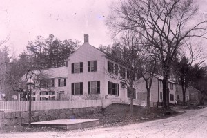
House Built around 1790
James White sold the land at 21-23-29 E Main St. to Thomas Elliot in 1783 (recorded 1807) 100 rods: Wingate and Elliot on w corner, w 3R, n 2.5 R on Elliot, w on highway 19.5R, s 7.5 R to former Samuel Chase land, e 20R on White to start. (179/261).
This house was built before 1798 when Thomas Elliott sold the land (along with 23 East Main Street) to Simeon Copp. Simeon had just married Mary Wadleigh b 1770 of West Newbury.
Simeon is the son of Josiah and Mary (Swett). Mary is the daughter of John Swett Jr. and Susannah (Page) Swett. When Susannah dies in 1739, Simeon and Mary inherit land.
It appears that Simeon and Mary moved to Gilmanton, NH as his son Josiah was born in Gilmanton, NH in 1781 and Simeon died in 1812 in Gilmanton.
Mary and Simeon sold off 23 East Main Street in 1801 to Willibe Wells.
This house, like many others in the neighborhood became a two family house owned by Daniel Swan, Thomas Emery, and Ruth Sealy. Around 1831, Benjamin Chase (and Betsy Ladd) acquired it and it then went to his decedents, first to Mary Jane (Fullington) then to Eustis Chase, then Eliza Hall.
In 1866, Daniel Donegan (Donnegan) purchased it from Daniel Hall and Eliza Hall (daughter of Ben and Betsy Chase) and the Donegan (Donnegan) family remained connected with the house until 1925.
In 1926, 21 East Main and 23 East Main seem to be owned by the same people, but are still separate properties.
Charles Ramsey purchased it from Donegan (Donnegan), had lost it to taxes but regained ownership of it and it went to their heir Edith Kane in 1964.
It was still in existence in 1967 as the Owen’s purchased it. As yet, it has not been determined when it was torn down.
Deeds
1789, Oct 27: James White Esq to Thomas Elliot (179/261). Starting at land of Joshua Wingate and running westerly 3R, then northerly 2.5 R on land of E. Elliott, then running westerly on highway 19.5R, then southerly 7.5R on land formerly owned by Samuel Chase, then easterly 20R on White’s land to bound first mentioned. This suggests a little jog of 2.5R by 3R bordering Colby Lane owned by E. Elliot.
1798, Apr 18: Thomas Elliott and Sarah Elliott to Simeon Copp (165/207) bounded by Ingalls on east (6R), Moses Moody on south (8R), west by Jonathan Tuscbury (Tewksbury?) (7.5R). About 50 rods with dwelling house.
| Daniel Swan? | |
| Daniel Swan? | |
| Daniel Swan?
|
|
| Daniel Swan?
|
|
| Swan | 1827, July 28: Daniel Swan to Thomas Emery (247/250). Nathan Chase on East (6R), David Elliot on South (30 feet), West by land of Swan, northerly by Road (30 feet) |
| Swan | 1830, Nov 20: Thomas and Mary Emery to Benjamin Chase (256/271) Nathan Chase on East (6R), David Elliot on South (30 feet), West by land of Swan, northerly by Road (30 feet) |
| 1836, Dec 1: George Foot to Ruth Sealy (342/219). Bounded by Road on North (38 feet), east by Daniel Swan (6R), South by David Elliot (38 Feet), west by David Elliott (6R). Containing about 15 Rods. | Benjamin Chase will #5097 November 1831 Benjamin listed as trader wife- Betsy 1/2 of house children: John Johnson Chase (leaves 1 story store in Rocks village), Eustice, Mary Jane Fullington & Ebenezer, Eliza J Hall & Daniel H Hall. In 1832 petition of heirs to divide real estate including William Eustis Chase minor with John S Morse guardian |
| 1839: Mary Jane Fullington and Ebenezer Fullington, Daniel Hall and Eliza J. Hall to Ruth Sealy for $10.00. Bounded by Main Street (4R) on North, Daniel Swan (8R) on west, David Elliott (4R) south, and Moses G. Jaques (7R) east. (342/218) Piece of land under and adjoining a certain shop the income and improvement of which our venerable father B. Chase gave his son John J. Chase during his natural life. | |
| 1853: Eustis Chase and Maryette Chase to Daniel Hall (534/071). Bounded by Moses Booking, late Daniel Swan (8R), Bookings, late David Elliott (5R), Moses Jaques (7R) and Highway. Said property given to John J. Chase during his natural life and then Eustis Chase by their honored father Benjamin Chase in his last will and testament. | |
| 1856, June 4: Daniel Hall to Amada Ayer, wife of Edmund B. Ayer, Sally (Sarah) McFee wife of Hamden McFee, and Edward P. Sealy (534/71) being property Daniel bought from Eustis Chase. | |
| 1856, June 7: From Edmond B. Ayer, Amanda M. Ayer, Hamden McFee, Sally McFee, Edward P. Sealy and Mary Sealy to Patrick Riley for $500.00 (600/234 deed) | |
| 1856, June 11: From Riley to Ayer et al (534/72) (mortgage?) | |
| 1866 (May 28): Daniel Donegan (Donnegan) (shoemaker) and Ellen Donegan (Donnegan) to Patrick Riley and Alice Riley for $365.00 (741/37mtg) Bounded on east by Moses Jaques 7R, south by Brookings 5R, west by Brookings 8 R, north by highway. | |
1866, May 28: Patrick and Alice Riley to Donegan (Donnegan). North by Road, east by Moses Jaques (7R) West by Brookings (5R) South by Brookings (8R). (705/201)
1870 Census:
Daniel Dunnigan (Donnegan) (38) works in shoe factory
Ellen (35) Keeps House
Matthew (16) works in shoe factory
Ellen (15) works in shoe factory
John (13) attends School
Daniel (11) attends School
Timothy (8) attends School
Julia (8) attends School
James (6) attends School
William H. (3) at home
Stephen (5 months) at home
1892 map lists Mrs. Donegan (Donnegan)
1900 Census
Ellen Donegan (Donnegan) (68)
Matthew (48) son – shoemaker
Daniel (19) grandson – shoemaker
John (12) grandson – at school
William (8) grandson – at school
1925, Sept 18: From heirs of Donegan (Donnegan) to Charles B. Ramsey for taxes owed of $12.86 (2648/214) Land and Buildings bounded by land of Thomas E. Quested, Frederick Kimball and Main Street. Lot 5, Block 7, Plat 430.
1939, Aug 1: to City of Haverhill for taxes (3194/461) Lot 5, Block 7 Plat 430 (10,000 sq ft.)
1942, Aug 17: Back to Ramsey redemption of taxes (3309/100)
1956 taken from Charles B. Ramsey (4314/409)
Ida M. Ramsey dies Sept 4, 1963
Idabell Ramsey (Williams) death cert: 26130/368. Husband listed as Forrest Ramsey death 1981.
1964: Charles and Ida Ramsey probate records #280713/280714 of probate court shows that dtr. Edith Kane, sole heir, inherited lot 5 and 6 of assessors map and she received permission from petition of 280713 to sell lot 5 for $500.00
1967, Feb 28: Edith J. Kane to Robert F. Owens and Patricia Owens (5428/632) lot 6.