John L. Esterbrook’s Barn (7)
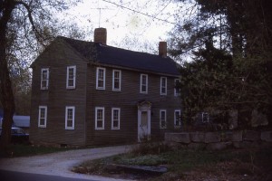
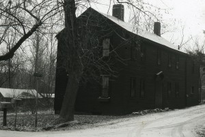
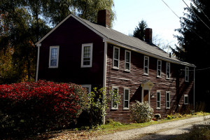
According to Noyes, this house was John R. Estabrook’s barn made into a home for his son John L. Esterbrook when he was married in 1860. It contained no fireplaces nor any of the fine old handwork of the older houses. It was moved to the corner of Colbys lane and East Main street.(7, pg33) However, John L. marries in 1865 and John R. has died by this time.
1850 census:
872-1099  John R. ESTERBROOKS, 36, carpenter
          Ann M. ", 32 (Hopkinson)d. Uriah and Lucy, Nov. 15, 1817
          John L. ", 5

1839: John R. Esterbrook (son of Joseph) was a justice of the peace and a carpenter.  He married Ann Matilda Hopkinson of Bradford on December 12, 1839.
1856 Map: J. R. Estabrook
1864 John R. Estabrook dies
1865: John L. and Mary Elliott marry
1870 Census:
John Esterbrook (25) works in shoe factory
Mary (27) keeps house
Albert (4) at home
Frank (2) at home
George J. Elliott (25 Works in shoe factory)
This could be 34 East Main
Mercy Colby (47) Keeps House
Lizzie (23) works in shoe factory
James (22) works in shoe factory
Stephen (21) works in shoe factory
Charles (16) works in shoe factory
Lorenzo (14) works in shoe factory
Carrie (12) attends school
Frank (7) attends School
1872 atlas lists Mrs Colby
1892 owned by Mrs. Jane Colby
Deeds/Probates:
1731/2 Feb 16: Samuel Batchelder to John Swett (60/159 (35 Acres)) bounded southeasterly by river, southwesterly by 12 rod way, nor’westerly on a bound that runs from Haverhill to Amesbury and Northeasterly on highway or road by the side of Swett’s Land.
1773, May 4: John Swett to Ephraim Elliot (179/261). Seems to be south of highway and bounded by land of John Swett. Bounded on north by landing or highway 9R, West by Swett 3R, South by Swett 8R, east 2R. No Buildings mentioned
1800, Apr 16: Ephraim Elliott and Thomas Elliott to Frederick Parker (169/84). Six rods of land and buildings bounded on north by Swett’s Landing 77′, on west by Moses Moody 63′, on south by Moses Moody 57′, and east by James Walker 54′ (James got land from Samuel Walker).
1804, Apr 6: Moses Moody to Frederick Parker (175/120). 10 rods of land and bounded as follows West by Moses Moody 87′, South by E. Foot 47′, East by E. Foot and James Walker 80′, North by Parker 45′ to bound first mentioned. Seems like this is south of 37 and west of 9 Wharf.
1809, July: Moses Moody dies, Probate record #18609
1810, December 15: Thomas and Sarah Elliott and Elizabeth Moody to Joseph Esterbrook (house-wright) (196/226) A certain piece of land and buildings beginning at the southerly side of highway and Frederick Parker and then running southerly to a stake and stone 10′ from the barn lately owned by Moses Moody (late of Haverhill), thence northwesterly by Thomas Elliot land 26′, thence about north to highway, thence easterly by highway 26′ to bound first mentioned.
1820: Frederick Parker Dies Probate record #20499
1827: Land seems to go to Joseph Estabrook when he marries Nancy (Ann) Parker (Frederick’s sister or mother??)
1835, March 25: Joseph and Ann Estabrook to Charles Minot. (282/092). 3 pieces of land included. #1: One acre of land bounded easterly by Merrimack River, southerly by land of Enoch Foot and Nathaniel Ladd, Westerly by land of Enoch Foot, Northerly by land of Nathaniel Ladd. #2: South side of road leading from Haverhilltown to Rock’s Bridge. south easterly by Ebenezer Fullington and Enoch Foot, southerly by E. Foot, westerly by land of Poyen and Joseph Estabrooks (occupied and tan yard bark mill and currying shop). #3: Northerly side of said road with dwelling house. (Francis Carr to Frederick Parker (1805 – 179/109), (175/120: Francis Carr to Frederick Parker May 10 1804) (Joseph Poyen to Frederick Parker 1804 (175/119). Charles Minot to Joseph Estabrook (282/94) mortgage?? Charles Minot is listed as a Counselor/Attorney in 1847 Haverhill.
1835 back to J Estabrook
1838, Dec 3: John Johnson and Ruth Johnson (1/2 in common undivided land) to Joseph Estabrook (388/244) bounded by William D. S. Chase, Moses George, Widow Kelly and Driftway) owned by late Phineas Nichols (might be up the hill)
1861, Feb 25th: From Joseph Estabrook Jr. to John R. Estabrook (618/110) Upon Joseph Sr. death.
1857: Samuel Elliott to Freeman F. Maynard (573/260). Starting at John R. Estabrook and running southerly by F. Parker to E. Foot, Westerly by E. Foot to Colby lane, north on Colby lane to John R. Esterbrook (seems like it is the small back portion.
1858: Freeman F. Maynard to Catherine F. Maynard (597/272) (small portion)
1861, Jan 30: John and Catherine H. Maynard to Hannah Ramsey (621/277). (small portion)
1861, Apr 26: Charles Ramsey to John R. Estabrook (621/278) (small portion)
1867, Aug 14th: Ann M. John L., and Mary E. Estabrook mortgage to Brickett (729/118) Land behind 37 E. Main street bounded by Eban Colby, Colby’s lane, John R. Estabrook. (mortgage) discharge: 788/189
1875, Aug 10: John L. Estabrook and Mary E. (Elliott) Estabrook to John B. Nichols, 2nd (934/258) bounded by E. Main, Colby Lane (private way) Eben Colby and T. J. Orne. (Mortgage) discharge (974/197)
1877, March 14: John L. Estabrook to Adoph Jutraes (973/50) $400.00
1877, March 14: Adoph Jutraes to Mary E. Estabrook (973/51) $450.00
1877, Apr 9: Mortgage by Georgetown Savings Bank by Mary E. and John L. Estabrook (974/35)
1881, June 14: Mary E. Estabrook to Hannah Jane Colby (wife of Abram Colby) (1067/140) 3/4 of an acre bounded , north by main street, east by T.J. Orne, west by Richard G. Colby, south by Eben Colby
Feb 7, 1896: Hannah J. Colby to Lizzie Mae True & Frank B. True (1490/164)
Did Lizzie M divorce True (or did True die) and she married Fred H. G. Chase? (also own store and sold in 1920.
March 15, 1918: Lizzie M. Chase to Angie B. Kent (1490/164)
1923, January 26: (3463/278): Angie B. Kent to Edward B. Germain 3/4 of acre more or less (I think this is the son of John Germain – the last toll keeper. Also lived 28 East Main Street??)
1940, Oct 5: Part of land from City of Haverhill to Frank Sweeney (on Wharf Lane) (3234/13) Maybe small wedge piece of land that bounces back and forth between 47 and 37 East Main Street in the 70s.
Sept 6, 1955: Edward B. Germain to Newton (4253/1) running along Colby’s lane 188′,9″ on various courses to land formerly owned by Eben Colby, thence easterly on Eban Colby land to land of T. J. Orne 84′, 6″, thence northerly 165′, 2″ to Main Street, then west on Main Street 47.91′.
March 15, 1966: Earle W. Newton and Josephine A. Newton to Robert F. Owens and Patricia Owens (5349/522)
Sept 7, 1966: Robert F. Owens and Patricia C. Owens to John R. Gagnon (5392/281) running along Colby’s lane 188′,9″ on various courses to land formerly owned by Eben Colby, thence easterly on Eban Colby land to land of T. J. Orne 84′, 6″, thence northerly 165′, 2″ to Main Street, then west on Main Street 47.91′.
1970, Oct 16: John R. Gagnon to John Belyea (5720/46) running along Colby’s lane 188′,9″ on various courses to land formerly owned by Eben Colby, thence easterly on Eban Colby land to land of T. J. Orne 84′, 6″, thence northerly 165′, 2″ to Main Street, then west on Main Street 47.91′.
1972, Apr 11: Sweeney to John W. O’Brien and Veronica M. O’Brien (5837/63). Along Main Street 117.39′ and 61′ to land owned by Whittimores, running southerly 94/74′ to Sweeney, then easterly 85.53′ to Gagnon then 136.82′ to main street. (seems like 37 and 47 East Main) See plan 1973 # 236
1973, May 10: John W. O’Brien and Veronica O’Brien to Gordon W. and Mabel M Ware Trustees of Keepsake Realty Trust (5973/373) along with 47 E. Main Street.
1973, May 10: Wares to Family Mutual Savings Bank (5973/374) mortgage for 37 adn 47 East Main.
1973, May 10: Gordon W. Wares and Mabel M. Wares to John W. and Judith G. Belyea (5979/531) Small pie slice of land for $100.00 that was attached to 47 E. Main Street
1975, Apr 9: John W. and Judith G. Belyea to Dana F. Brownell and Norma A. Brownwell. Both parcels of land (37 and triangle) (6138/765) Mortgage 6138/770 between parties discharge (6287/186) 1st piece: running along Colby’s lane 188′,9″ on various courses to land formerly owned by Eben Colby, thence easterly on Eban Colby land to land of T. J. Orne 84′, 6″, thence northerly165′, 2″ to Main Street, then west on Main Street 47.91′. 2nd piece: 27.62′ along Main Street, 80′ on east, southerly 86.10′ (same as 10635/3) (small triangle between 37 and 47 East Main)
1975, Jul 7: Brownell to Family Mutual Savings Bank (7858/167)
1976, Oct 7: Brownell to Wares (6287/19) Both parcels of land (37 and triangle) (6138/765) Mortgage 6138/770 between parties discharge (6287/186) 1st piece: running along Colby’s lane 188′,9″ on various courses to land formerly owned by Eben Colby, thence easterly on Eban Colby land to land of T. J. Orne 84′, 6″, thence northerly165′, 2″ to Main Street, then west on Main Street 47.91′. 2nd piece: 27.62′ along Main Street, 80′ on east, southerly 86.10′ (same as 10635/3) (small triangle between 37 and 47 East Main) (mortgage with Family Mutual Savings (6827/20) $47,500
1990: Gordon W. Wares and Mable M. Wares to Herbert W. Colby & Lori H. Colby (10635/3) 1st piece: running along Colby’s lane 188′,9″ on various courses to land formerly owned by Eben Colby, thence easterly on Eban Colby land to land of T. J. Orne 84′, 6″, thence northerly165′, 2″ to Main Street, then west on Main Street 47.91′. 2nd piece: 27.62′ along Main Street, 80′ on east, southerly 86.10′ (same as 10635/3) (small triangle between 37 and 47 East Main)
1993, Feb 5: Herbert W. Colby and Lori H. Colby (owners of 37 East Main) and Richard and Jennifer Siegl (owners of 14 Colby’s Lane) for 10′ wide way between Lot 1, Block 6 (although deed says block 7)and Plat 430 and Lot 11 Block7, Plat 430 to connect (11735/399)
1990: Nov 16: Herbert W. Colby to Robert A. Welch (12724/174) (2 parcels of Land) 1st piece: running along Colby’s lane 188′,9″ on various courses to land formerly owned by Eben Colby, thence easterly on Eban Colby land to land of T. J. Orne 84′, 6″, thence northerly165′, 2″ to Main Street, then west on Main Street 47.91′. 2nd piece: 27.62′ along Main Street, 80′ on east, southerly 86.10′ (same as 10635/3) (small triangle between 37 and 47 East Main)
1997: Dec: Robert A. Welch to Stuart A. Meurer and Susan Bragg Meurer (14484/39)
2001: Stuart A. Meurer and Susan Bragg Meurer to Chad and Tonya Leitz (17316/534)