1778 – J Swett dies, he wills his house,barn, 16A land, ferry to grandson James White who then operates the ferry
1781, Nov 25: James and Eunice White (Haverhill Yeoman) (grandson of John Swett) to Joshua Wingate (Amesbury – trader) (141/3). One hundred and 20 pounds. Certain piece of and with dwelling house beginning on landing and running 2R to open way (James White allowed), south on open way 9R, west on land of White 9R, north by white 9R13′, east by Elliot 5R, north by Elliott 2R to beginning bound. 80 rods of land more or less. Fifth day of October in the year of our Lord one thousand seven hundred eighty one in the first year of our independence.
1791, March 11: Ephraim Elliott and Mary (Wingate) Elliott (Haverhill Gentleman) to William Cutler (Newburyport merchant) (153/66). A certain Distilling house. Bound by public landing on east, north by highway 77.5′, west by Joshua Wingate 46, south by Wingate 38′.
1795, Dec 23: Joshua Wingate and Hannah (Carr) Wingate to Dr. William Abbott (159/297). A lot of land with buildings bounded as follows. North by landing 2 Rods, East 10.5 R by a 2.5 Rod way to land of Swan, Southerly by land of Swan and land of Foster 12.5 R to land of Moses Moody. Running Northerly on Moody land 4.5R, Easterly on Moody 4 rods, northerly on Moody 2.5 R to land of Cutler, Easterly on land of Cutler 5R then North 2 R to bound first mentioned.
1797, June 26: Dr. Abbott to William Little (163/147). Starting at Cutler Distillery and running 2R along landing easterly, then southerly 2R, then westerly 3R to land of Cutler then northerly to bound first mentioned.
Perhaps building was constructed at this point because the next deed is the first one listing a building.
1797, June 26: William Little to Zebulaon Ingersoll (161/245). Land with Brick Building bounded by Cutler’s Distillery. 2 rods along “landing” (east Main), 2 rods along a 2-rod way, 3 rods on south, 2 rods on west by Cutler. (32 x 32 x 48 x 32).
1793 – 1799: Zebulon Ingersoll Account Book shows many neighbors purchasing goods from him. Many paid their accounts by items rather that cash.
1812: Enoch Foot is listed as a retailer. “Retailer of spirituous liquors”
1815 – June 7 – “Mr. Foot has moved his goods into the shop which he bought of my father at $400.” (from John Ingersoll’s day book)
1815, May 30: Zebulon Ingersol to Enoch Foot (207/166) bounded as follows. Beginning at corner of store and running westerly by landing about 2 rods to the land formerly of Moses Moody esq. but now of Ephraim B. Horne. Then running southerly about 2 rods to land of Foot. Easterly by Foot’s land to a private way, then Northerly by private way about 2 rods to beginning.
1830 Census shows Enoch Foot as a Merchant in Rocks Village (38)
1850 Enoch Foot probate 39253
1850, Sept 16: From George Foot to Samuel C. Foot (441/72) Part of estate. 12 Rods. Intending to convey Brick Store & Back Store & 1 foot beyond & the land under the same. Formerly owned by Enoch Foot Esq. Deceased.
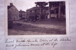
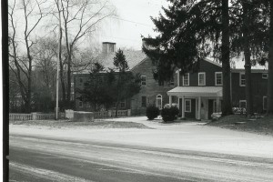
Captain-Deacon John Foot's Brick Store. Also owned by Zebulon Ingersoll, Maynard, Sawyer.

1850 census (not sure where they live)
828-1046  John FOOT, 48, laborer
          Sarah (Rollins) ", 55
          Abby ", 18
          Elmira MAYNARD, 33
          Hannah MCFEE, 47
1850 Census:
John Ladd -59, shoemaker
Sophia (Jaques)- 54,
Byron G. (Jan. 6, 1828) – 22, shoemaker,
George W. (June 15, 1830) – 20, shoemaker,
Elizabeth C (May 31, 1824) – 15,
Louisa M. (Mar. 25, 1840) – 10
1855 Census (between Tompkins and E. Chase)
Moses Gile (39) Shoecutter
Elizabeth C. Gile (30)
George W. Gile (15)
Charles H. Gile (1)
1856, May 22: Daniel Hall and Eliza Hall to Moses Brookings (533/101) “Intending to convey the brick store formerly owned by Enoch Foot deceased and the back store therewithin connected and the land under the same and one foot beyond. Bounded on the south by land held in trust by Abby F. Tompkins and on the west formerly owned by Benjamin Chase Esq. deceased and North and East by road and lane.
1857, Sept 2: Moses Brookings and Adeline Brookings to John w Ladd and Sarah E Ladd (558/39) bounded on south by Enoch Foot deceased, on west by Ben chase (deceased), east main and wharf lane.
1814, Aug 25 John Ladd marries Sophia Jaques. John was the son of Nathaniel Ladd II and Sally Noyes who lived in the Silloway Tavern on Wharf Lane.
1819: Sophia Brown Ladd born
1830 Census: John Ladd is listed as Comb Manufacturer in Rocks’ Village
1856 – John W. Ladd was tollkeeper of the bridge and a shoemaker in the cobbler’s stall by the bridge. Has he moved to the Toll Keepers house next to HTH at this point? Yes
1864: John W. Ladd to Elmira Maynard (671/138) $237.00 (bounded by Eben Colby on South, Swett’s Lane, Main Street, and William Sawyer on West) Excluding the privy which belonged to other parties.
1865 Census
Elmira Maynard (48) Trader (born in Marlborough Mass)
Catherine L. Maynard (44) Tailoress (born in Marlborough Mass)
1870 Census
Elmira Maynard (53) keeps house
Catherine (49) keeps fancy goods
1872 city directory: Ms. Almira Maynard, home and variety store near bridge. Also listed, Ms. Kate Maynard (sister of Almira)
Perhaps Elimira gave it to her sister in law Sarah A (wife of F. F)
1909: Sarah A. Maynard to F. Forrest Maynard (1989/118). Bounded by land owned by Mr. Russell. Wharf lane and East Main Street
1925, May 8: F. Forrest Maynard to Haverhill Coop Bank (Mortgage) (2640-140) discharge: 2924/250
Sarah Augustus Maynard, 13, born Sept. 24, 1836.
1931, Aug 21: F. Forrest Maynard to Frank Keezer (2924/290).
1932, Jul 28: Frank Keezer and Lillian M. Keezer to James Hill (2924/251) plus taxes for 1932. 12 square rods bounded on north by road, east by Wharf Lane, North by East Main Street, Westerly by Russell, Southerly by Frisbee. Being the same property from John Ladd to Elmira Maynard in 1864 (671/138) and 1989/118.
1940 Census: James Hill – 50, Bridget A. – 44, Winifred – 9, James – 6
James Hill to Bridget Hill (widow) through probate: 208462
1950, Aug 18: Bridgett Agness Hill to Langmaid (3763/189)
1952, Nov 13: Robert Vance Langmaid and Mary V. Langmaid to Mawhinney (3939/565)
1956, Nov 14: Guy L. Mawhinney and Madeline H. Mawhinney to Dam (4330/75). 12 square rods bounded on north by road, east by Wharf Lane, North by East Main Street, Westerly by Russell, Southerly by Frisbee.
1964, Aug 5: Richard and Shirley A. Dam to Edwin C. and Georgina Y. Whittemore (5195/70)
1971, Aug 20 : Edwin C. Whittemore and Georgina Y. Whittemore to James M. Bullock and Leslie T. Bullock (5797/598) $17,500
1976, Nov 10: James M. Bullock and Leslie T. Bullock to Pieter B. Voorhees and Garrett S. Voorhees (6303/196)
1991, May 20: Pieter B. Voorhees to Garrett S. Voorhees (11034/526)
2014, Oct 10: Garrett S. Voorhees to Thomas W. H. Beer, trustee of Thomas W. H. Beer Revocable Realty Trust (33614/485) Bounded by 33′ on East Main, 94.74′ along McKinnon (47 E. Main), 50.65′ along Sweeney (9 Wharf Lane), and 79.19′ by Wharf Lane.
foot-store-plan
The brick of the building is laid in a pattern so as to make the building as sturdy as possible. The bricks are laid in a 1, 5 common bond pattern; this means that there are five rows of stretchers (longer side of the brick) for header row (short end of the brick) of brick. This allows for bricks to form a sturdier pattern of interlocking rows. Observing the type of bond pattern the brick is laid in is helpful in determining when a building was constructed. Although knowing the pattern does not give an exact date it can narrow the time frame down as certain brick patterns were used before concrete was invented, and vice versa (only certain patterns were used once concrete was used in construction). Also only certain brick patterns were used in high style buildings or on portions of buildings which could be observed by the public (Flemish bond).
References
https://haverhill.pastperfectonline.com/photo/14CB0604-E2A3-4319-81D4-746824774670