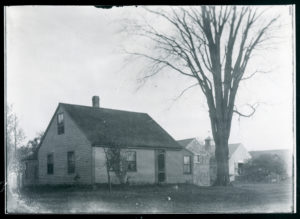
Some photos indicate that this was the Poyen Comb Factory and the Thompson House. Deeds to not support that.
1787: William sells 140 acres of father’s land in Haverhill and 6 acres of Marsh land in Newbury to Amos.(147/111)
1796, Oct 10: Francis and Mary Carr to Amos George. Bounded by William Little, Timothy Saunders, public Highway, driftway. (162/121)
1810, Amos purchases several large tracts of land along East Broad way (190/67-69)
1817, Aug 9: Amos George to Moses D. George (216/17) 5 acres , Highway 42R by 19R. $75.00 Running southeast on way 42R, then southwesterly 19R, then northwesterly 42 Rods to highway, then northwest 19R on way.
Moses George and Abigail Bodwell Ladd get married in May of 1818.
Moses and Abigail build a house on the land closest to 12 Rod way which then gets sold to Gideon through 753/20. (40R x 7R piece)
1829, July 2: Moses George to Gideon B. George (753/19). 39R 22L by Moses George on east, 2R 10L on south by Hazen Kimball, 39R 15L on west by Kimball, 2R 10L on north by highway. $17.00
Moses dies Feb 10, 1851.
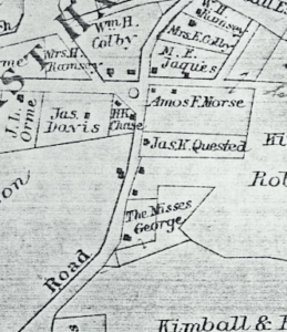
1851 Map shows Moses George
In 1855 some of Moses’ land sold to John Johnson through executor Frederick Parker. (618/240)
1868, May 19: A. B. L. George to Gideon George (753/20). On road from rocks bridge to Chain Ferry. Beginning at the northerly corner of highway and running southeasterly by land of formerly of Moses D. George 39 9/10 R, then southwesterly by land of Hazen Kimball 39 6/10 rod, to said highway then northeasterly by highway 2 4/10 rod to beginning containing about 95 rods. $50.00
1868, May 19: A. B. L. George to Gideon George (753/20) one undivided fourth part. Certain parcel of land with building’s thereon, on the road leading from Rocks Bridge to Chain Ferry. Beginning at the westerly corner at the road and running north easterly 7R7L to angle and then running southeasterly by land formerly of Mr. Ladd 40.5 road to a corner then southwesterly by Hazen Kimball 7R9L to bound then northwesterly by my own land 40R to bound first begun. Containing 1 acre 3 rods and 15 rods. $37.50
Abigail dies Aug 10, 1868.
1868, Nov 3 or 23: Abby W. (George) Goss wife of Daniel T. Goss, Elizabeth F. (George) Colby and William W. Colby, Wallace T. George and Sarah F. (Kenison) George, and G. B. George and Sophia A. (Ross) George to James K. Quested (766/119) for $375.00 39 9/10 R (660ft) by Moses and Abigail Ladd George on east, 2 4/10 (39′) by Hazen Kimball on south, 39 6/10R by Kimball on West, 2 4/10R on N by highway. 95R. Certain parcel of land with building’s thereon, on the road leading from Rocks Bridge to Chain Ferry. Beginning at the westerly corner at the road and running north easterly 7R7L to angle and then running southeasterly by land formerly of Mr. Ladd 40.5 road to a corner then southwesterly by Hazen Kimball 7R9L to bound then northwesterly by land of Gideon B. George 40R to bound first begun. Containing 1 acre and 3 rods (766/120). These are all children of Moses D. George/Abigail Bodwell Ladd, Amos/Sarah Green and Sarah Nichols, Gideon/Elizabeth Jewett, John/Ann Swaddock. No house
1868, Nov 3: Gideon B. George and Sophia A. (Ross) George to James K. Quested. (766/119) for $25.00. On road from rocks bridge to Chain Ferry. Beginning at the northerly corner of highway and running southeasterly by land of the heirs of Moses D. George and Abigail Bodwell Ladd George 39 9/10 R, then southwesterly by land of Hazen Kimball 39 6/10 rod, to said highway then northeasterly by highway 2 4/10 rod to beginning containing about 95 rods ~0.6 acres.
1868, Nov 23: Abby (George) and Daniel Goss, Elizabeth (George) and William Colby, Wallace T. George and Sarah F. (Kennison), William and Sarah George, Gideon B. and Sophia George (children of Moses, grandchildren of Amos) to James K. Quested (766/120) Northerly by Highway 7R 7L (~130ft), Easterly by John Ladd 40.5R, southerly by Hazen Kimball 7R 9L and easterly by Gideon B. George 40R.
1881 Map: Jas. K. Quested indicates that there is a house.
1893, Sept 12: James K. Quested and Mary A. Quested to William H. Ramsey. On the road leading from Rocks Bridge to Groveland Bridge. A certain piece of land with dwelling house and other buildings. Beginning at the westerly corner at the road and land of Hazen Kimball, the easterly by road 7R7L to land of Thomas J. Murphy, then northeasterly 40.5 road to land of said Kimball, then southwesterly 7R9L to bound then northwesterly 40R to bound first begun. Containing 1 acre and 3 rods. Reserving the right to enter upon and remove from hen house for one year. (1393/213)
1916, Jan 1: William H. Ramsey, Rosina Ramsey to Carrie O. and Asa M. Kimball. Mortgage (2333/326). Discharged (2758/545 in March 1928). See 2761/200
1918, July 9: George F. Ramsey administrator of estate of William H. Ramsey to Ida L. Russ (2395/272) 2.5 acres dwelling house and barn.
1921, May 19: Ida L. Russ to Hicks Containing 2.5 acres (2528/392)
1928, March 21: Eliza B. and Mary U. Hicks to Charles A. Ladieu (2758/546)
1928, March 29: Gertrude O. Damon and Wilbert L. Quested to Elias B. and Mary U. Hicks (2758/545) same as 766/119
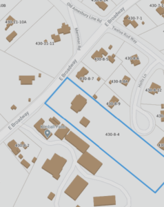
1933, Feb 28: George G. Davis, Administrator of estate of Charles A. Ladieu to William H. Thompson. Northerly by East Broadway 160 ft, Easterly by land owned by Thomas J. Murphy 660 ft, Southerly by land of Frederick Kimball 160 ft, Westerly by Frederick Kimball 660 ft. (2951/340) $2,200
1995, Apr 3, William H. Thompson to Dorothy T. and Francis J. Lavallee (13008/529) Probate #: 87P0241-E1 (William got from Margaret or May Thompson through probate.
2003, Apr 30: Dorothy T. and Francis J. Lavallee to Brian W. Desmariais (21087/318)
2010, Sept 27: Brian W. Desmarais to Brian W. Desmarais and Monica C. Calabro-Desmarais. 160ft on east broadway, Easterly by Thomas J. Murphy 660 ft, Southerly Frederick Kimball 160ft, westerly by Frederick Kimball 660, containing 2.5 acres. (29809/20)