1742 – J Swett sells his 19A north of E Main St. to Simeon Brown. Still owns
south side land (35 acres). 87/139
1773, July 3: Henry Young Brown, Simeon Brown, and Ruth Brown to James Carr (Innholder) (134/22) 19 acres bounded by Jamaco path, Road from Kingston to Swett’s Ferry, two rod way allowed by John Swett. The whole north side of East Main.
1774, Sept 7: James Carr innholder To Francis Carr of Almsbury, cooper, 19A dwelling house all other buildings bounded by highway west(?) from bound rock to Jamaica path then s on Jam path to road from Kingston to Swetts ferry then on said road e to Ephraim Elliots upon said road then on Elliots n to s&s then Elliots s to the road or landing then on landing e to a 2-rod way Swett allowed then on said way n to the way from bound rock to Jam path (start). 134/ 23
1803: From Francis and Mary Carr to John Johnson Jr. (176/259). 110 Rods of land bounded by Swett’s Landing 9R 6L – south, Store 24L, East – Highway 11R 4L, North – Carr 9R 1L, and west – Carr/Joseph Poyen Land 13R 12L. Carr’s dwelling house, barn, outhouses, and Cooper shop on Swett’s landing.
1807, John Johnson and Ruth to Ben Chase. (183/74). 6.5 Rods of land with buildings bounded start at s corner at stone, n by Parker 2R17l to stone to my own land, e by my own land 2R 20l to stone, s by my own land 2R 3l to stone at road leading to Merrimack bridge, w by sd road 2R 12.5l to start.
1832: Benjamin Chase (Benjamin, David, John, Aquilla) kept a grocery store in the brick building on the corner of Swett’s lane. (Rebecca’s Gleaning’s has a story about Harry Spoollet (pg 106)
1833, Mar 5: Benjamin, s. Benjamin, jr. married Betsy (Ladd)
1836: in probate 5116 for Ephraim Chase, a notice was put in Fullington’s store.
1845, Feb 25: Ebenezer Fullington to Eustis Chase (351/205) A lot northerly of said highway with store bounded by Parker on west, Joseph Estabrook or north, John Johnson on East, highway on South.(previously owned by Benjamin Chase) along with a portion of the Daniel Chase House. $1,350 includes 47 East Main.
1846, Oct7: Mortgage between Eustis Chase and Nicholas White (372/196) Discharge: 1860, June 18 (601/161) In 1855 mortgage gets assigned to Adeline Brooking (515/291). Includes 47 East Main.
Land formerly owned by Ebenezer Fullington. (7)
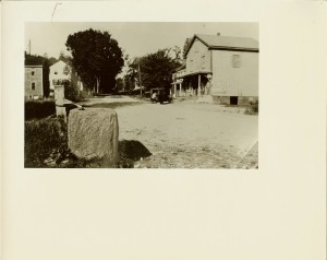
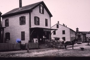
William Sawyer kept a grocery store in a building owned by J.B. Nichols, 2nd and later he bought Col. Johnson Tavern and had his store there. (Tavern burned December 19, 1920.
Listed as Samuel D. Maynard’s store in 1850.
1850 listed as Maynard Store on Map
1850 census
825-1043
Samuel D. MAYNARD, 38, trader, $500
          Sarah (George)", 33
          Sarah Augustus", 13, born Sept. 24, 1836.
          Ellen Stowe", 10, born Apr. 20, 1840
          Sarah GEORGE, (73 mother of Sarah)

Samuel D. Maynard, born Mar. 19, 1811
Sally (Sarah) George, d. Maj. Amos and Sarah (Nichols), born Sept. 24, 1817.
Samuel D Maynard., marries Sally George, Oct. 15, 1835.
1853, Mar 31: Eliza Nichols to Eustis Chase (477/251) bounded by west Parker, North Estabrook, East formerly John Johnson now Daniel Hall and McQuestin
1853, Apr 11: Nicholas White of Newton in Rockingham county to Eustis Chase (477/251). “A lot with a store thereon”. same description of above.
1853, Apr 11: Eustis Chase and Maryette Chase to Samuel S. Maynard (477/252)
1857, Oct 8: Samuel S. Maynard to Freeman F. Maynard (573/262). Southerly by Highway, Westerly by Frederick Parker, Northerly by Joseph Estabrook and Easterly by James Davis.
1858: Freeman F. Maynard to Catherine H. Maynard (597/272)
1860, Dec 28: John H. Maynard and Catherine H. Maynard to Otis Mann (618/220) same piece of land sold by Davis to Maynard (Apr 28, 1860). This might be a small part of Tavern land. same land on 5xx/99 in 1858) Looks like mortgage.
1861, Feb 5: John H. and Catherine H Maynard to Philena W. Nichols (618/54) bounded west and north by Joseph Estabrook, south by road, east by Otis Mann.
John B. Nichols’ Store(7)
1865 Census:
John B. Nichols II (44) Trader
Philena W. Nichols (43) housework
1888-1910: William Sawyer lived at 47 East Main. He kept a grocery in the building owned by J.B. Nichols, 2nd at 42 East main. Later he bought Col. John Johnson’s Tavern and had his store in the upper end.
1870 census:
John B. Nichols (49) grocer
Felina (48) keeps house
Mary A. (18) no employment
Lizzie Bartlett (14) attends School
1891 Map lists it as P.O.
1902 Haverhill and Groveland Directory lists William H. Sawyer as Clerk of Post Office in RV. Mail leaves at 10:30 am, arrives at 4:00 pm.
1900 John B. Nichols has moved into Phineas Nichols house. He is 76 and has Trues for servants.
1900 census: Alice Foster (43) widowed
1902 Haverhill City Directory: Alice Foster, Widow of William F. off Main
1904, November 15: George M. J. Nichols administer of J. B. Nichols, 2nd estate to E. F. Gay(1763/128). Northerly and Westerly by Estabrook, southerly by Main Street, Easterly by Joseph Mann
1905: May 16: Ella F. Gay to McCann (1777, 123) McCann to Charles G. Woodbridge??
1906, June 12: John A. McCann and Agnes B. McCann (1827/416)
1907, June 8: Thomas Neville to George B. Sears (1878/119)
1918, Feb 16: George B. Sears and Jennie W. Sears to Royal G. Snow and Adela E. Snow (2387/5) Mortgage owned by Oda Howe Nichols and George B. Sears
1918, Feb 27: Royal G. Snow to Samuel D. Estabrooks (2387/232)
1921, January 4: Samuel D. Esterbrooks and Tryphena A.B.Estabrooks to Samuel L. Hicks (2473/557). Southerly by Main Street, Westerly and northerly by land formerly owned by Joseph Esterbrooks, now Bragdon, easterly by land formerly owned by Otis Mann, now Sawyer.
1921, Jan 10: Samuel L. Hicks to George B. Sears (mortgage) (2473/558)
1921, Jan 10: Samuel L. Hicks to Samuel D. Esterbrook (2473/558)(discharge: 2515/391)
1922, May 9: Samuel L. Hicks to Citizens bank (2515/85)discharge (2887/252)
1929, Jun 15: Flora M. (Hicks) Osborne and H. Louis Osborne to John R. Hufford (2809/505) mortgages.
1937, October 1: William H. and Vilena Hartford to City (3127/361 orig lean)
Dec 8, 1945: deed transitions (3431/359). Really 34-36 lot
osburne got it as heir to hicks osburne to hufford (2809/505)
1940 Census: Lester Gates – 21, Addie Gates -20
1/3 of land: Florence M. Osborne and Herbert M. Osborne to Leroy B and Pearl A. Patten: Probate 196767, June 6, 1940 (3220/58)
1/3 of land: May 20, 1944: Louise M. Waterhouse guardian of Benjamin L. Patten to Leroy B. Patten (3369/548)
1944, Aug 1: Leroy B Patten and Pearl A. Patten to Helen G Wallace (3377/379)
1946, July 8: City of Haverhill to Jay L. Collins ( 3494/320)
1950, Sept 18: J. L. Collins to Charles C. McClean and N. Louis McClean (371/286)
Leroy B .Patte and pearl a patten to Wallace (3377/379)
patten got it thru probate 196767 1940 (3220/58) from osborne and Louise Waterhouse 3369/548 in 1944 one undivided 1/3
1956, Aug 14: Truman B. and Helen G. Wallace to Charles G. and Florence M. Stewart
1970: Charles G and Florence M. Stewart(bk4296/423)