1742 – J Swett sells his 19A north of E Main St. to Simeon Brown. Still owns
south side land (35 acres). 87/139
1773, July 3: Henry Young Brown (Brownfield Maine), Simeon Brown (Haverhill Blacksmith), and Ruth Brown (Kingston, NH, Mantle maker) to James Carr (Innholder) (134/22) 19 acres bounded northerly by the highway that leads from the bound rock to Jamaco path and westerly on Jamaco path, southerly on the highway that leads from Kingston to Swett’s ferry in part and in part on the landing easterly on a two rod way that leads from the landing to the road from the bound rock which two rod road was allowed by John Swett. The whole north side of East Main. (146 pounds, 13 shillings, 4 pence)
1774, Sept 7: James Carr innholder To Francis Carr of Almsbury, cooper, 19A dwelling house all other buildings bounded by highway west(?) from bound rock to Jamaica path then s on Jam path to road from Kingston to Swetts ferry then on said road e to Ephraim Elliots upon said road then on Elliots n to s&s then Elliots s to the road or landing then on landing e to a 2-rod way Swett allowed then on said way n to the way from bound rock to Jam path (start). 134/ 23
1803: From Francis and Mary Carr to John Johnson Jr. (176/259). 110 Rods of land bounded by Swett’s Landing 9R 6L – south, Store 24L, East – Highway 11R 4L, North – Carr 9R 1L, and west – Carr/Joseph Poyen Land 13R 12L. Carr’s dwelling house, barn, outhouses, and Cooper shop on Swett’s landing.
1828, Apr 16: John Johnson, Jr. and Ruth to Humphrey Hoyt (248/210) same as 251/11 and 282/92. He is the grandson of John Hoyt and Abby Nichols (aunt of Phineas Nichols).
1828, Sept 1: Humphrey and Alice B. Hoyt to Sarah Sawyer widow (251/11). Beginning at the northerly corner and the road and running westerly 5R 20L on land of Abigail Parker to land of Ben Chase. Running southerly on Chase land 4 rods to stake and stone then easterly on land of John Johnson 6R to the road thence northerly on road to bound first mentioned.
1834: Sarah Sawyer (widow) to Joseph Estabrook (282/92) bounded on North – Abigail Parker 5R 20L, West – Benjamin Chase 4R, and South – John Johnson Esq 6R, east – Road 4R.
1852, June 15: From Joseph (Joiner) and Anna (Parker) Estabrook to John Osgood (Cordswainer) for $100.00 (482/270) bounded on east by River Road 64′, on north by Joseph Estabrook land 66′ on west by Joseph Estabrook 64′, on south by Hall and McQueston 66′.
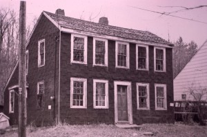
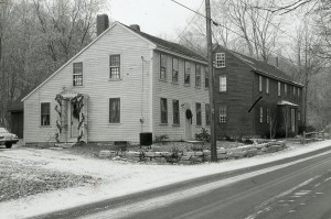
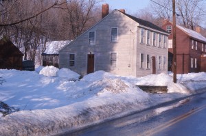
1850-1853: Half of John Swett/Thomas Elliott & Sarah Swett Tavern moved from 28 East Main Street. John is listed as cordwainer and living in Haverhill when he buys the land for 12 River Road in 1852.
Not in Village in 1830 Census
1850 census;
884-1112  John OSGOOD, 36, shoemaker (b. ~ 1814)
          Elizabeth ", 32 (b. 1818)
          John ", 16 (b. 1834 - d. 1867)
          Eliza ", 2 (b. 1848)

From andover: Harriot, d. twin, John and Elizabeth, Feb. 9, 1812.
Isaac, s. twin, John and Elizabeth, Feb. 8, 1812.
1850: Listed as John Osgood on Map (shoemaker and expressman)
1855 Census:
John Osgood (46) Shoemaker
Elizabeth Osgood (41)
Lizzie Osgood (6)
William Elliot (24) Shoemaker (NH)
1856 map lists John Osgood
John Osgood is in the Protector #3 company from 1864-1865
1864, Sep 15: James and Lydia (Morse) Davis to John Osgood (674/123). A piece of land bounded as follows, beginning on the southeasterly corner of Osgood land and running southerly 30′, then westerly by land of Osgood 106′, then north by the land of heirs if Joseph Estabrook 30′, then running easterly partially by heirs and partially by Osgood 104′ to bound first mentioned.
Two John Osgoods are listed as living in RV in 1870. Both are listed as Shoemakers
1870 Census: John Osgood (55) (born 1814) shoecutter
Elizabeth Osgood (48) (born 1822) (keeps house)
Lizzie (22) born (1848) works in shoe factory
Sara M. (14) born (1856) attends school
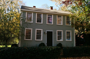
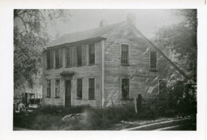
1875/6: Captain John Osgood occupied it for many years, moving his family to the city in 1878 (Cpt John Osgood dies 1892)
1872 map lists Osgood
1880 – 1888: James Tarelton – shoemaker and on Protector No. 3 roster with Charles and George A. Tarelton
1900 census
Heresa W. Kelly (33) divorced
Grace Kelly (18) daughter
Lizzie S.(1848 – xx) (d. of Jonathan Osgood (July 12, 1811 – 1892) and Elizabeth B. Cooper (1816 – 1896)) marries James H. Murray (1845 Canada – xx) in 1906. She was 56 and he was 61 when they married.
Sarah M. (1856 – xx) (d. of Jonathan Osgood (July 12, 1811 – 1892) and Elizabeth B. Cooper (1816 – 1896)) marries James Monroe Tarelton (1825 Epsom, NH-1897) in xxx.
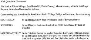
1924, Jan 5: Lizzie S. Murray and Sarah M. Tarelton to Joseph William Hull and Sadie (Sarah) L. (Hartford) Hull (2590/31) bounded by Easterly by River Road 94 ft, Southerly by Sawyer land 106 ft, westerly by Bragdon 38 ft, and Northerly by Bragdon 30 ft, westerly by Bragdon 64 ft, to land of Carr, Easterly by land of Carr 69ft 5 inch to beginning. Neither husband is on deed. James Tarelton died in 1897.
1925 – 1945: Joseph and Sadie Hull (Sadie’s probate: 220981, Joseph W. Probate: 220735
1940: Arvilla Gile
1940 Census: Joseph W. Hull – 54, Sadie L. – 64, Arilla Gile – 36 (lodger), Charles H. Tuckwell – 79 (lodger)
1945: Charles Tuckwell (1861-xx) 1880, 1900, 1910 he lives in Merrimac, 1920, 1940 in Haverhill
1948- 1965: Wm. Hartford (1876-1957) and Vhilena Hartford (1890 – 1985 greenwood)
1965: Louis and Annette Hartford (Louis is Wm Jr’s son)
1968, Sept 23: Vhilena Hartford, taking of taxes (5559/780) Plat 430, Lot 5, Block 3
1969, Jul 2, Vhilena Hartford, redemption of taxes (5619/514)
1970, Sept 22, Vhilena Hartford, taxing of taxes (5713/735)
1971, July 22: Vhilena Hartford, redemption of taxes (5786/119)
1967 – 1975: Vacant
1970: Vhilena M. Hartford
1974, Oct 15: Vhilena M. Hartford sold to Jerry Lischke for $100.00 (6119/513) (bounded by land of Sawyer, Bragdon, Carr. (previously owned by Joseph W. and Sadie Hull) (2590/31)
1974, Dec 20: Almon W. Hartford (Vhilena’s son) sells land to Lischke for $8,000. (bounded by Sawyer, Bragdon, Carr (previously owned by Joseph W. Hull) (6119/512)
1975, Apr: Jerry C. and Catherine E. Lischke to Paul K. McDonnell and Carol E. McDonnell (6142/417) $37,500.
1976 – 1984: Paul R. and Marie E. Charron (6233/495) $43,500
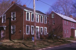
1979: Paul Charron (On Feb 22, a fire broke out on second floor, page 13 of Merrimac/Amesbury Messenger)
1984 – 1986: Katherine Butler (7408/540) Plat 471, Block 3, lot 5. Back taxes to be paid.
1986 – 1988: Homequity, Inc. (9516/239)
1988 -1993: Peter R. and Anita M. Zafris (9516/241)
1993 -1995: Fred Pickard and Sheila Pickard (11918/488) $149,000
1995 – 2010: Gregory Brucato
2010: Suzanne Coffin
Pained chimney saltbox forms (https://www.sec.state.ma.us/mhc/mhcpdf/townreports/Essex/hvr.pdf