1870: Charles Elliot Ordway, s. Theodore, shoemaker, June 24, 1847. Listed as b. next to bridge in 1870. This may mean business next to bridge (so could be guard shack/Toll house/shoe shop)
1850 census (probably not this property - could be 21 River Road or in Toll House when it was located )
812-1036  Theodore ORDWAY, 50, shoemaker
          Mary ", 43
          Hazen ", 20, shoemaker
          Ann ", 14
          Ellen ", 7
          Charles ", 3
          Moses LITTLE, 25, shoemaker
          Abraham CHASE, 24, shoemaker
          James C. ELLSWORTH, 40, shoemaker, $4000
          Elizabeth ORDWAY, 18

Theodore Ordway married Mary Carr Elliott in 1828
1850: J. W. Ladd
1855 Census:
John W. Ladd (33) Trader
Sarah C. Ladd (31)
Frances A. Ladd (11) female
Mae S. H. Ladd (8)
John E. Ladd (7)
Sarah P. Ladd (3)
George W. Ladd (25) Shoe Manufacturing
Thomas G. Bradley (23) Shoemaker
Maybe also Lynn Bard Ladd (3)
1870 Census (could also be Sawyer Store)
Theodore Ordway (71) works in shoe factory
Mary Ordway (64) keeps house
Charles E. (22) works in shoe factory
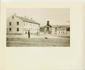
Originally between the Hand Tub House and the Toll House.
1742, Sept 30: John Swett to Barnabus Bradbury (82/159) Bounded westerly by land of Swett 2R, northerly by land of Swett 6.5R, easterly by river 2R and southerly by Bradbury 9r.
1748, Aug 5: Barnabus Bradbury of Amesbury (Innholder) to Gideon Challis (98/216) House and Barn. Bounded westerly by two rod way 4R 9′, Southerly 5R 10′, easterly by river 4R 9′. 76.5 Rods total.
Challis moved to Gloucester where he died.
1751, Sept 9: Gideon Challis (Shipwright) sold to John Greenleaf for 26 pounds, 13 shillings and 4 pence (106/144) land and dwelling house. Bounded southerly by Barnabus Bradbury, Northwesterly on land of Simeon Brown and William Morse, easterly by river and north easterly by land of Simeon Brown and William Morse. 1/3 of an acres
– willed to Benjamin Greenleaf. Benjamin occupied it for many years and then sold to Phineas Nichols in 1770. He remodeled it into two tenements which he rented. The piece of land bordered the Merrimac river, joined land on the south already owned by Mr. Nichols and was bounded on the north-west and north-east by William Morse which was of Simeon Brown. (26) Probate #11762 dated 1769.
1770, Feb 21: Benjamin Greenleaf to Phineas Nichols (139/172). Bounded north westerly and north easterly by William Morse which was late the estate of Simeon Brown, Southerly by Phineas Nichols, easterly by River. Same as land sold from Gideon Challis to John Greenleaf 1751, Sept 9.
1782, : Phineas Nichols and Anne (Saunders) Nichols to Zebulon Ingersoll (141/101). 10R along River Road, Northerly 5R 10′, southerly on River 9R 6′, Southerly by Samuel Esterbrook SE land to Road 4R 3.5′, then southerly 14′, then westerly 25′ to road again. Except for land with Blacksmith shop.
1798: Zeb Ingersoll and Ruth (Ingersoll) to Enos Bartlett (164/6). 9R 3′ on River, 5R 10′ on north by Samuel Woodbury, and 10R on road. From River on SE land to Road 4R 3.5′, then southerly 14′, then westerly 25′ to road again.
1799, Sep 18: Enos Bartlett
Enos Bartlett Probate dated 1808: #1868 (William Pillsbury administrator)
Wife seems to be Sarah. Most land in Newbury.
Enos dies in 1800. Son’s John, Jonas, Isaac, and Enos (dies 1807).
Several Deeds in 1810 190/250 ish seem to sell off his land.
Missing how it gets from Enos Bartlett to Simeon Copps
Molly Noyes married Simeon Copps, Dec 24, 1794 could be his second wife (first Sarah Fellows)
Simeon is son of Josiah Copps and Mary Swett.
1802, Apr 26: Simeon Copps and Mary (Noyes) to Silas Pilsbury (170/288) same land as (177/49)
1805, Sep 16: Moses and Mary (George) Copps to Joseph de Poyen (177/49). Land and buildings bounded by Highway 9R2′, north by Sewell Short 5R 10′, River 9R 6′, John Brown and Aaron Peasley on south 5r12′.
1805 Sewell (Suil) Short
1808, Feb 1: Sewell Short and Judith (Dow) Short to Cutting Moody Jr. (185/33). On East 4.5 R along river , on south by Joseph Poyen 7R, Highway 4.5R, North John Brown 7R.
1822, Nov 11: Joseph and Sarah (Elliott) de Poyen to Edward S. Moody (Brother of Cutting)(232/73). Land and buildings bounded by Highway 9R2′, north by Cutting Moody 5R 10′, River 9R 6′, John Brown on south.
1823, Sept 23: Edward S. Moody and Abigail (George) Moody to Cutting Moody (234/10). Same as above
1877, Nov 7: Dwelling house upon land leased of the City of Haverhill. From Elizabeth E. Poyen, Albert E. Kenison, John W. L. Kenison, Hannah W. Kension to Abigail Kenison (988/236) Land of the original location
1881 Map shows building in its original location next to HTH.
1892 Map show building in its original location next to the HTH.
1872, Feb 10: (948/89): Heirs of Elizabeth Nichols sells off small piece of land from Phineas Nichols estate to Eliza and Ann Nichols (Maidens). 45′ by Ramsey (previously Burrill), 112 northerly along J. B. Nichols, 29′ to road and 112 feet down road to beginning.
1876, Feb 28: Elizabeth Nichols (Widow of Jacob?) to John B. Nichols, Grocer (948/89) (bounded by 29′ land of Nichols, southerly 29′ land of Nichols, easterly land of Eliza and Ann Nichols, northerly along road to beginning)
1904, Sept 17: George M. J. Nichols (administer of estate of John B. Nichols 2nd) to Charles G. Woodbridge (1755/360). North by Hunkins 160′, south by Moulton 210′, East on River 220′, west on Merrimac Road 300′. (35 and 29 River Road)
Timothy Kinison died 21st of December, 1876, probate in 1877 number 44122. Names John W. L., Abby, Albert, and Elizabeth de Poyen. John B. Nichols, Frederick Kimball, and Thomas J. Orne are the committee.
Homestead: $2000
House in Lane: $550 (could this be land he acquired from Enoch Foot (370/169) in 1846? (bounded by Mary Woodbury’s 3rd and Merriam Ladd’s (widow of Nathaniel Ladd) 3rd)
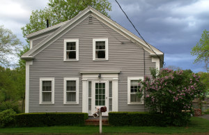
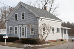
House in Rocks Bridge: $450 (moved onto River Road turn of century)
1/2 Hotel: $500
Farm in Merrimac: $1800
Meadow: $50.00
13 acres Woodland: $275.00
Farm in Newbury: $4,130
Woodland in Georgetown: $290.00
Sept 17, 1904: C. E. Robinson to Charles C. Woodbridge (1770/350) ( mortgage). North by Hunkins 160′, south by Moulton 210′, East on River 220′, west on Merrimac Road 300′. (35 and 29 River Road)
1905, Mar 20: Charles G. Woodbridge to Clarence E. Robinson (1770/349) bounded by Bridge St (formerly Merrimac Road), North by Hunkins 160′, south by Moulton 210′, East on River 220′, west on Merrimac Road 300′.(35 and 29 river road)
1905, March 20: Ursula Woodbridge to Clarence E. Robinson (1770/349) North by Hunkins 160′, south by Moulton 210′, East on River 220′, west on Merrimac Road 300′. (35 and 29 River Road)
1910, Oct 27: Robinson to Hayward (2051/446). North by Hunkins 160′, south by Moulton 210′, East on River 220′, west on Merrimac Road 300′. (35 and 29 River Road)
1913, Jun 30: George E. Hayward and Mary M. Hayward to Clarence E. Robinson (2229/2) North by Hunkins 160′, south by Moulton 210′, East on River 220′, west on Merrimac Road 300′. (35 and 29 River Road)
1915, Jan 1: Clarence E. Robinson to Harold H. Sawyer (2284/515) bounded by Bridge Street 129′, land of Emma L. Moulton 210′, River 100′ and on North by Clarence E. Robinson. (29 river Road)
1915, Jan 1: Harold H. Sawyer to Emma G. Willard (2284/516) (Mortgage). bounded by Bridge Street 129′, land of Emma L. Moulton 210′, River 100′ and on North by Clarence E. Robinson.
1917: Harold H. Sawyer and Alice E. Sawyer to Frank A. Smith (2464/36) bounded by Bridge Street 129′, land of Emma L. Moulton 210′, River 100′ and on North by Clarence E. Robinson.
1929, Nov 21: Frank Albert Smith to Frances E. (Follett) Smith (his wife) (2829/263). 129 feet on road, 210 feet on south (Emma L. Moulton), 100′ on river and 190 feet on North (Clarence E. Robinson)
1940 Census: Frank A. Smith – 45, Frances E. – 48, Frank – 16 (Son)
March 8, 1946: Franc(es) Elizabeth Smith to Francis A. Smith Jr. (3444/123). 129 feet on road, 210 feet on south (Emma L. Moulton), 100′ on river and 190 feet on North (Clarence E. Robinson)
July 28, 1967: Frank A. Smith Jr. (195 – xx) to Frank A. Smith Jr. (1924 – 2012) and Annette B. Smith (5465/274)