Listed as John Swett house 1730 in RVHD (1974)
1742 – J Swett sells his 19A north of E Main St. to Simeon Brown. Still owns
south side land (35 acres). 87/139. No mention of buildings.
1760 Simeon bequeths to his wife Hannah (who remarried Benjamin French) in 1760 “about 20 acres of land in Haverhill with buildings thereon standing”
1773, July 3: Henry Young Brown, Simeon Brown, and Ruth Brown to James Carr (Innholder) (134/22) 19 acres bounded by Jamaco path, Road from Kingston to Swett’s Ferry, two rod way allowed by John Swett. The whole north side of East Main. No mention of buildings
1774, Sept 7: James Carr innholder To Francis Carr of Almsbury, cooper, 19A dwelling house all other buildings bounded by highway west(?) from bound rock to Jamaica path then s on Jam path to road from Kingston to Swetts ferry then on said road e to Ephraim Elliots upon said road then on Elliots n to s&s then Elliots s to the road or landing then on landing e to a 2-rod way Swett allowed then on said way n to the way from bound rock to Jam path (start). 134/ 23
1789, July 15: Francis Carr (trader) and Mary (Elliott) Carr to Samuel Carr (a cooper) for 40 pounds. 7.5R by 3R5feet (54′) (150/120) Bounded by Ephraim Elliot on west and Francis Carr on north and east, road on south. No Buildings mentioned.
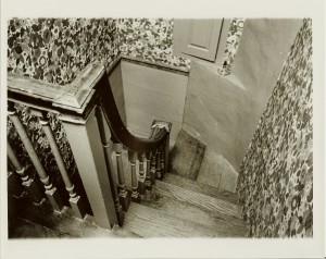
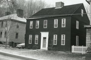
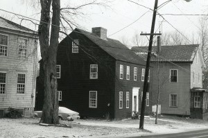
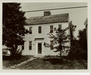
Samuel Carr, a young cooper, built this center chimney house in about 1785 (more likely 1789). Although only a few areas of paneling and some original doors survive, its six fireplaces – of which five are in corners – are in working order including the large keeping room hearth. The front “captain’s staircase” is particularly graceful. (34)
1790 census: Carr, Sam’l: 1 male over 16, 3 under 16, 1 female
1793, Oct 21: Samuel Carr and Sarah Carr sold to Wm L. Abbott M.D. for 120 pounds (158/121) bounded southerly by road, westerly by Moses Moody, Northerly by Francis Carr, and easterly by Francis Carr. “With all the buildings therein standing”. (7.5R x 3r5.5 feet)
1797, Apr 3: William L. and Abigail Abbott sell to Walter Little (162/126) (7.5R x 3r5.5 feet) 25R of land.
1797, Oct 28: Walter Little and Sally Little to Joseph Poyen (164/30) One 1/2 land and 1/2 building Landing on South, Moses Moody on West 7R, North Francis Carr 3R, 5.5feet, East by Francis Carr 7.5R, Landing 3R, 5.5feet. $350.00
1798, Apr 12: Walter and Sally Little to Jethro Pearson (163/140). 1/2 lot, 1/2 house and 1/2 barn. Bounded by Highway 3r 5.5′, east – Moses Moody 7.5R, North – Francis Carr 3R 5.5′, East – Francis Carr 7.5R. $350.00
1798, Aug 10: Jethro Pearson and Poley Pearson to Walter Little (164/118). 1/2 half a lot ad compleat half of building. Bounded by Highway 3r 5.5′, east – Moses Moody 7.5R, North – Francis Carr 3R 5.5′, East – Francis Carr 7.5R. $300.00
1803, June 28: Walter Little to Joseph Poyen (172/207) 1/2 lot and 1/2 building bounded as follows. Westerly by Moses Moody 7.5R, Northerly 3R5feet, Easterly 7.5R by Francis Carr, South 3R 5f by landing. $312.00
1804, Nov 20: Joseph Poyen to Frederick Parker (175/119) land and building bounded as follows: West by Moses Moody 7.5 R, North by Francis Carr 3R 5feet, Easterly by John Johnson 7.5R, Southerly Road 3R 5feet. $800.00
1804, Nov 20: Two other deed 175/119 – Moses Moody to Parker and 175/120 – Francis Carr to Parker seem to increase this land size.
Frederick Parker marries Abigail Burroughs of Amesbury, int. Mar. 5, 1796
Frederick dies July 8, 1820, a. 49 y.
Probate for Abigail his wife, Ann his mother and Nancy his sister. Enoch Foot, Benjamin Chase, and John Osgood, Probate committee.
Potentially, Joseph Estabrook gets this land because he marries Ann Parker in 1827 (maybe Frederick’s mother/sister)
1835, March 25: Joseph and Ann Estabrook to Charles Minot. (282/092). 3 pieces of land included. #1: One acre of land bounded easterly by Merrimack River, southerly by land of Enoch Foot and Nathaniel Ladd, Westerly by land of Enoch Foot, Northerly by land of Nathaniel Ladd. #2: South side of road leading from Haverhilltown to Rock’s Bridge. south easterly by Ebenezer Fullington and Enoch Foot, southerly by E. Foot, westerly by land of Poyen and Joseph Estabrooks (occupied and tan yard bark mill and currying shop). #3: Northerly side of said road with dwelling house. (Francis Carr to Frederick Parker (1805 – 179/109), (175/120: Francis Carr to Frederick Parker May 10 1804) (Joseph Poyen to Frederick Parker 1804 (175/119). Charles Minot to Joseph Estabrook (282/94) mortgage?? Charles Minot is listed as a Counselor/Attorney in 1847 Haverhill.
1840, Jan 17: Joseph Estabrook to William Ashby. (316/258). five acres and two dwelling houses on north side of road leading from Rocks Village to Haverhill Town. Beginning at southeasterly stake and stone on corner of road and Ebenezer Fullington, running North by land of Fullington, Easterly by land of John Johnson to a road. Northerly by road to Back Road. Westerly by Back Road to land of John Johnson Jr. Then Southerly by land of Johnson to Road and first point. Mortgage: 497.70 to be paid within 1 year with interest.
Oct 20, 1849 John R. Esterbrook sold to D. H. Hall and John J. Mcquesten. (7) not necessarily this land. Might be 21/23 east main street.
1850 census
861-1087  Joseph EASTERBROOKS, 64, carpenter, $600
          Anna ", 71  (Parker??)
          Sarah ", 31
1853 (or 1833) by Frederick Parker. (7, pg33) Questionable as Parker dies in 1820.
1856 Map: J. Estabrook
1855 Census:
John R. Estabrook (41) Carpenter
Ann M. Estabrook (36)
John L. Estabrook (11)
1861, Feb 25th: From Joseph Estabrook Jr. to John R. Estabrook (618/110) Upon Joseph Sr. death. This contained 8 acres and was considered Joseph’s homestead.
John R. dies in 1864
1865 Census:
Ann M. Estabrook (47) Shoe Sticher – Widow
John L. Estabrook (20) Cordwainer
1865
1865 Census
Joseph Estabrook (55) farmer
Hannah Estabrook (53) housework
Addie Morse (17)
Charlie Morse (1)
could these be the children of Sophia W. who marries Nathaniel Morse in 1837? Sophia was Samuel III’s daughter .
1867, Apr 29: Ann M Estabrook (John L’s mother, John R’s wife), J. L. Estabrook and Mary E. Estabrook to Lydia A. Davis (727/138), Due to $2000 debt to Davis in will. $1,300 for this piece and 34 Wharf Lane. 5 acres more or less.
1868, March 30: Lydia A. Davis to A. J. Young (from New London, NH) (743/157) $1000.00. 5 acres more or less. This deed also includes 34 Wharf Lane.
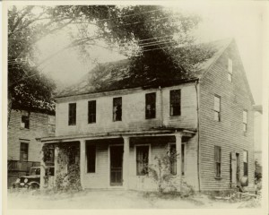
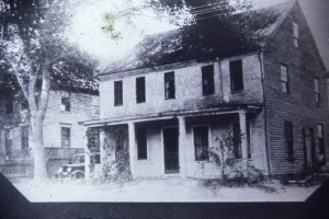
According to Noyes, A. J. Young remodeled the house and the 15 light windows were replaced with new ones and the fireplaces taken (7, pg33)
1870 Census:
Andrew J. Young (39) carpenter
Hattie (37 or 39) keeps house
Aura (14) attends School
Ernest (12) attends school
Burton Young (11) attends school (b. Mar 27, 1855, died Apr 5, 1876)
1889, Jan 11: Andrew J. Young to C. B. Young (1240/233) for $1.00 and other considerations. Beginning at the highway near Abigail George land then easterly to Mr. Elliot land, northerly to land of Hayden Brown
1889, Dec 10: C. B. Young (unmarried) to Andrew J. Young (1273/16) A certain lot of land with Buildings. Beginning at highway and land of Abigail George thence westerly by Abigail George to land of Mr. Elliot, then northerly by land of Elliot and land of Hayden Brown, thence westerly by land of Hayden Brown, then northerly by Brown’s land to road leading from Rocks Village to South Amesbury, then easterly and southerly by said road to Ann W. Esterbrook and others, thence westerly and southerly and southeasterly by land of said Ann W. and others to land of John Osgood, thence southerly by Osgood’s land, thence westerly then southerly by Osgood’s land and land of James Davis and others to land of John B. Nichols, thence westerly and southerly by said Nichols land to the road first mentioned and then easterly by road to the bound first mentioned. Easterly is underlined to suggest this is incorrect.
1892: Listed as A. Young
1894, July 30: Andrew Young to John N. Hunkins and Flora A. Hunkins (1419/35)
1900 Census:
Sarah Thompson (50) single
Henry R. Thompson (44) brother – widowed
Emma E. Thompson (35) librarian – single
1905, Sept 6: Hunkins to Merrimac Savings Bank (1791/409)
1912, Nov 27:(2186/290-292) Merrimac Savings Bank to Bragdon. Discharge 3520/97 in 1947.
1930, March 26: Augustus I. Bragdon to Andrew O. Nicol and Mary H. Nicol (2839/386) about 5 acres
1930, March 26: Andrew O. Nicol and Mary H. Nicol to Merrimack Valley Development Corp (2839/387) (mortgage?) about 5 acres
1948, Nov 30: Merrimack Valley Development Corp. to Carroll L. Barton (3546/588) about 5 acres
1952: Taken for Taxes from Carroll L. Barton (3914/257) redemption in 1963 3984/568. 4.3 acres Lot3 Block 3, plat 430.
1956: taken for taxes: (4319/369)
1959, Sept 14: Joan Bancroft To Carroll L Barton and Mary A. Barton(4599/39) – about 5 acres
A.J. Young had it remodeled and it was at this time that the fifteen-light windows were replaced with new ones and the fireplaces taken.
Carroll L. Barton sold to Jerry Lischke in 1974 for 19,000. (Parcel two?)
Carroll L. Barton and Mary A. Barton sold to Joan Bancroft in 1959. boarded by Carr/Osgood, brown, wood
1970: Carol L. Barton (bk4599/39)
1971, Apr 22: Carroll L. Barton and Mary A. Barton sold to Lischke (5760/441) ($10,100)
Owned by Merrimac Savings Bank at one point (70’s?)
Olmstead to Lischkke in 1986
1974, Aug 15: Jerry C. Lischke and Catherine E. Lischke sold to Joel F. Rubinstein and Nancy G. Rubinstein
1974, Aug 15: Easement for 42 East Main Street (6092/734) Florence M. Stuart vs. Frank Sweeney. Easement for septic system.
1993, May 25:Joel Rubinstein to Jonathan E. Wagman and Robin J. Smeland May 25, 1993
Parcel one:
A certain parcel of land, together with the buildings thereon, situated at the now numbered 38 East Main Street in Haverhill, Essex County, Massachusetts, being shown as Parcel A on a plan of land entitled “Subdivision Plan of Land in Haverhill, MA., 1975, by Arnold and Associates 80 Buttonwoods Avenue, Haverhill, Owned by Jerry C & Catherine E. Lischke, ” dated November 1975, by Arnold and Associated, 80 Buttonwoods Avenue, Haverhill, Massachusetts recorded with Essex South District Registry of Deeds in Plan Book 136, Plan 20. Parcel two book 5436, Page 85.